
Topografische kaart Badian
Interactieve kaart
Klik op de kaart om de hoogte weer te geven.
Over deze kaart
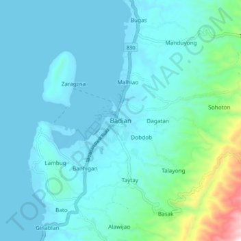
Naam: Topografische kaart Badian, hoogte, reliëf.
Locatie: Badian, Cebu, Central Visayas, 6031, Philippines (9.83013 123.35898 9.91013 123.43898)
Gemiddelde hoogte: 113 m
Minimale hoogte: -3 m
Maximale hoogte: 874 m
Andere topografische kaarten
Klik op een kaart om zijn topografie, zijn hoogte en zijn reliëf te bekijken.
Busay
Philippines > Cebu > Busay
Busay, Cebu, Central Visayas, 6000, Philippines
Gemiddelde hoogte: 225 m
Gilutongan Island
Philippines > Cebu > Lapu-Lapu
Gilutongan Island, Lapu-Lapu, Cebu, Central Visayas, Philippines
Gemiddelde hoogte: 0 m