
Topografische kaart Oslob
Interactieve kaart
Klik op de kaart om de hoogte weer te geven.
Oslob
Generally, topography of the area is hilly and rolling, dominated by open grasslands and second growth forest. There are fairly level and rolling plateaus and valleys spread throughout the interior. These are some of the most suitable areas for upland agriculture. The highest mountain peak is 800 metres (2,600 ft) above sea level.
Over deze kaart
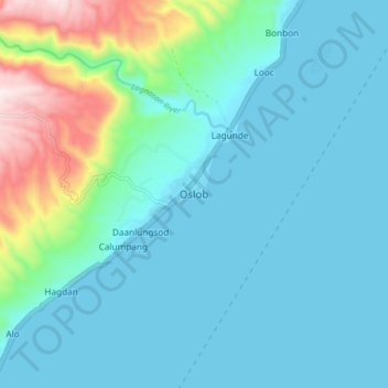
Naam: Topografische kaart Oslob, hoogte, reliëf.
Locatie: Oslob, Cebu, Central Visayas, Philippines (9.48045 123.39352 9.56045 123.47352)
Gemiddelde hoogte: 118 m
Minimale hoogte: 0 m
Maximale hoogte: 700 m
Andere topografische kaarten
Klik op een kaart om zijn topografie, zijn hoogte en zijn reliëf te bekijken.