Topografische kaart Lone Tree
Klik op de kaart om de hoogte weer te geven.
Lone Tree
Lone Tree is located on the northern border of Douglas County, directly adjacent to Arapahoe County, approximately 18 miles (29 km) south of downtown Denver. Neighboring communities include Centennial to the north, Highlands Ranch to the west, and Parker to the southeast. The Meridian International Business Center, a major office and business park, lies immediately north of the city in unincorporated Arapahoe County. According to the United States Census Bureau, the city has a total area of 9.81 square miles (25.4 km²), all of it land, at an elevation of 6,010 feet (1,832 m).
Over deze kaart
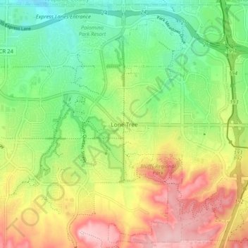
Naam: Topografische kaart Lone Tree, hoogte, reliëf.
Locatie: Lone Tree, Douglas County, Colorado, 80124, United States (39.50710 -104.90935 39.56648 -104.82991)
Gemiddelde hoogte: 1.818 m
Minimale hoogte: 1.730 m
Maximale hoogte: 1.938 m
Andere topografische kaarten
Klik op een kaart om zijn topografie, zijn hoogte en zijn reliëf te bekijken.




Hidden Mesa Open Space
United States > Colorado > Douglas County > Castle Rock
Gemiddelde hoogte: 1.902 m