
Topografische kaart Larkspur
Klik op de kaart om de hoogte weer te geven.
Over deze kaart
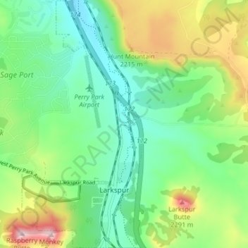
Naam: Topografische kaart Larkspur, hoogte, reliëf.
Locatie: Larkspur, Douglas County, Colorado, United States (39.21697 -104.90889 39.26753 -104.87743)
Gemiddelde hoogte: 2.102 m
Minimale hoogte: 1.990 m
Maximale hoogte: 2.339 m
Andere topografische kaarten
Klik op een kaart om zijn topografie, zijn hoogte en zijn reliëf te bekijken.
Castle Rock
United States > Colorado > Douglas County
Castle Rock is located at 39°22′20″N 104°51′22″W / 39.37222°N 104.85611°W / 39.37222; -104.85611 (39.372212, −104.856090) at an elevation of 6,224 feet (1,897 m). Castle Rock is in central Colorado at the junction of Interstate 25 and State Highway 86, 28 mi (45 km) south of downtown…
Gemiddelde hoogte: 1.952 m
Parker
United States > Colorado > Douglas County
Parker is located in northeastern Douglas County. Its northernmost border follows the Arapahoe County line, and the city of Aurora touches the town's northeast border. The center of Parker is 23 miles (37 km) southeast of downtown Denver. Castle Rock, the Douglas County seat, is 15 miles (24 km) to the…
Gemiddelde hoogte: 1.845 m
Highlands Ranch
United States > Colorado > Douglas County > Highlands Ranch
Gemiddelde hoogte: 1.761 m
Castle Pines
United States > Colorado > Douglas County
Castle Pines is located at 39°28′18″N 104°53′41″W / 39.471742°N 104.894827°W / 39.471742; -104.894827 (39.471742, -104.894827) at an elevation of 6,368 feet (1,941 m). Located on Interstate 25 in central Colorado, Castle Pines is 20 mi (32 km) south of downtown Denver and 43 mi (69 km)…
Gemiddelde hoogte: 1.924 m
Castle Rock
United States > Colorado > Douglas County
Castle Rock is located at 39°22′20″N 104°51′22″W / 39.37222°N 104.85611°W / 39.37222; -104.85611 (39.372212, −104.856090) at an elevation of 6,224 feet (1,897 m). Castle Rock is in central Colorado at the junction of Interstate 25 and State Highway 86, 28 mi (45 km) south of downtown…
Gemiddelde hoogte: 1.952 m
Parker
United States > Colorado > Douglas County
Parker is located in northeastern Douglas County. Its northernmost border follows the Arapahoe County line, and the city of Aurora touches the town's northeast border. The center of Parker is 23 miles (37 km) southeast of downtown Denver. Castle Rock, the Douglas County seat, is 15 miles (24 km) to the…
Gemiddelde hoogte: 1.845 m
Highlands Ranch
United States > Colorado > Douglas County > Highlands Ranch
Gemiddelde hoogte: 1.761 m
Lone Tree
United States > Colorado > Douglas County
Lone Tree is located on the northern border of Douglas County, directly adjacent to Arapahoe County, approximately 18 miles (29 km) south of downtown Denver. Neighboring communities include Centennial to the north, Highlands Ranch to the west, and Parker to the southeast. The Meridian International Business…
Gemiddelde hoogte: 1.818 m
Castle Pines
United States > Colorado > Douglas County
Castle Pines is located at 39°28′18″N 104°53′41″W / 39.471742°N 104.894827°W / 39.471742; -104.894827 (39.471742, -104.894827) at an elevation of 6,368 feet (1,941 m). Located on Interstate 25 in central Colorado, Castle Pines is 20 mi (32 km) south of downtown Denver and 43 mi (69 km)…
Gemiddelde hoogte: 1.924 m
Parker
United States > Colorado > Douglas County
Parker is located in northeastern Douglas County. Its northernmost border follows the Arapahoe County line, and the city of Aurora touches the town's northeast border. The center of Parker is 23 miles (37 km) southeast of downtown Denver. Castle Rock, the Douglas County seat, is 15 miles (24 km) to the…
Gemiddelde hoogte: 1.845 m
Castle Rock
United States > Colorado > Douglas County
Castle Rock is located at 39°22′20″N 104°51′22″W / 39.37222°N 104.85611°W / 39.37222; -104.85611 (39.372212, −104.856090) at an elevation of 6,224 feet (1,897 m). Castle Rock is in central Colorado at the junction of Interstate 25 and State Highway 86, 28 mi (45 km) south of downtown…
Gemiddelde hoogte: 1.952 m