
Doe een donatie
Rust jezelf uit voor je volgende avontuur:
Als Amazon-partner verdient deze site een commissie op in aanmerking komende aankopen, zonder extra kosten voor jou.
Topografische kaart Franktown
Klik op de kaart om de hoogte weer te geven.
Doe een donatie
Rust jezelf uit voor je volgende avontuur:
Als Amazon-partner verdient deze site een commissie op in aanmerking komende aankopen, zonder extra kosten voor jou.
Over deze kaart
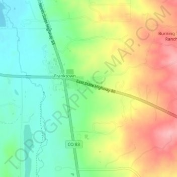
Naam: Topografische kaart Franktown, hoogte, reliëf.
Locatie: Franktown, Douglas County, Colorado, United States (39.38144 -104.76016 39.39732 -104.73768)
Gemiddelde hoogte: 1.898 m
Minimale hoogte: 1.846 m
Maximale hoogte: 1.965 m
Doe een donatie
Rust jezelf uit voor je volgende avontuur:
Als Amazon-partner verdient deze site een commissie op in aanmerking komende aankopen, zonder extra kosten voor jou.
Andere topografische kaarten
Klik op een kaart om zijn topografie, zijn hoogte en zijn reliëf te bekijken.
Parker
United States > Colorado > Douglas County
Parker is located in northeastern Douglas County. Its northernmost border follows the Arapahoe County line, and the city of Aurora touches the town's northeast border. The center of Parker is 23 miles (37 km) southeast of downtown Denver. Castle Rock, the Douglas County seat, is 15 miles (24 km) to the…
Gemiddelde hoogte: 1.845 m
Castle Rock
United States > Colorado > Douglas County
Castle Rock is located at 39°22′20″N 104°51′22″W / 39.37222°N 104.85611°W / 39.37222; -104.85611 (39.372212, −104.856090) at an elevation of 6,224 feet (1,897 m). Castle Rock is in central Colorado at the junction of Interstate 25 and State Highway 86, 28 mi (45 km) south of downtown…
Gemiddelde hoogte: 1.952 m
Doe een donatie
Rust jezelf uit voor je volgende avontuur:
Als Amazon-partner verdient deze site een commissie op in aanmerking komende aankopen, zonder extra kosten voor jou.
Parker
United States > Colorado > Douglas County
Parker is located in northeastern Douglas County. Its northernmost border follows the Arapahoe County line, and the city of Aurora touches the town's northeast border. The center of Parker is 23 miles (37 km) southeast of downtown Denver. Castle Rock, the Douglas County seat, is 15 miles (24 km) to the…
Gemiddelde hoogte: 1.845 m
Castle Pines
United States > Colorado > Douglas County
Castle Pines is located at 39°28′18″N 104°53′41″W / 39.471742°N 104.894827°W / 39.471742; -104.894827 (39.471742, -104.894827) at an elevation of 6,368 feet (1,941 m). Located on Interstate 25 in central Colorado, Castle Pines is 20 mi (32 km) south of downtown Denver and 43 mi (69 km)…
Gemiddelde hoogte: 1.924 m
Doe een donatie
Rust jezelf uit voor je volgende avontuur:
Als Amazon-partner verdient deze site een commissie op in aanmerking komende aankopen, zonder extra kosten voor jou.
Highlands Ranch
United States > Colorado > Douglas County > Highlands Ranch
Gemiddelde hoogte: 1.761 m
Castle Pines
United States > Colorado > Douglas County
Castle Pines is located at 39°28′18″N 104°53′41″W / 39.471742°N 104.894827°W / 39.471742; -104.894827 (39.471742, -104.894827) at an elevation of 6,368 feet (1,941 m). Located on Interstate 25 in central Colorado, Castle Pines is 20 mi (32 km) south of downtown Denver and 43 mi (69 km)…
Gemiddelde hoogte: 1.924 m
Doe een donatie
Rust jezelf uit voor je volgende avontuur:
Als Amazon-partner verdient deze site een commissie op in aanmerking komende aankopen, zonder extra kosten voor jou.
Doe een donatie
Rust jezelf uit voor je volgende avontuur:
Als Amazon-partner verdient deze site een commissie op in aanmerking komende aankopen, zonder extra kosten voor jou.
Castle Rock
United States > Colorado > Douglas County
Castle Rock is located at 39°22′20″N 104°51′22″W / 39.37222°N 104.85611°W / 39.37222; -104.85611 (39.372212, −104.856090) at an elevation of 6,224 feet (1,897 m). Castle Rock is in central Colorado at the junction of Interstate 25 and State Highway 86, 28 mi (45 km) south of downtown…
Gemiddelde hoogte: 1.952 m
Doe een donatie
Rust jezelf uit voor je volgende avontuur:
Als Amazon-partner verdient deze site een commissie op in aanmerking komende aankopen, zonder extra kosten voor jou.