
Topografische kaart Molina
Klik op de kaart om de hoogte weer te geven.
Over deze kaart
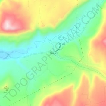
Naam: Topografische kaart Molina, hoogte, reliëf.
Locatie: Molina, Mesa County, Colorado, 81646, United States (39.16915 -108.08035 39.20915 -108.04035)
Gemiddelde hoogte: 1.794 m
Minimale hoogte: 1.629 m
Maximale hoogte: 2.026 m
Andere topografische kaarten
Klik op een kaart om zijn topografie, zijn hoogte en zijn reliëf te bekijken.
Fruita
United States > Colorado > Mesa County
The original town site was planned for 80 acres (32 ha) with a park in the middle. The first water reached the town from the Colorado River in 1907. By 1909, the town center was linked with electricity. In the 1930s, Fruita participated in several government projects, including the Grand Valley Resettlement…
Gemiddelde hoogte: 1.400 m
Colorado River
United States > Colorado > Mesa County > Clifton
The entire eastern boundary of the Colorado River Basin runs along the North American Continental Divide and is defined largely by the Rocky Mountains and the Rio Grande Basin. The Wind River Range in Wyoming marks the northern extent of the basin, and is separated from the Colorado Rockies by the endorheic…
Gemiddelde hoogte: 1.417 m
Fruita
United States > Colorado > Mesa County
The original town site was planned for 80 acres (32 ha) with a park in the middle. The first water reached the town from the Colorado River in 1907. By 1909, the town center was linked with electricity. In the 1930s, Fruita participated in several government projects, including the Grand Valley Resettlement…
Gemiddelde hoogte: 1.400 m
Colorado River
United States > Colorado > Mesa County
The entire eastern boundary of the Colorado River Basin runs along the North American Continental Divide and is defined largely by the Rocky Mountains and the Rio Grande Basin. The Wind River Range in Wyoming marks the northern extent of the basin, and is separated from the Colorado Rockies by the endorheic…
Gemiddelde hoogte: 1.417 m
Colorado National Monument
United States > Colorado > Mesa County > Grand Junction
Gemiddelde hoogte: 1.809 m