
Topografische kaart De Beque
Klik op de kaart om de hoogte weer te geven.
Over deze kaart
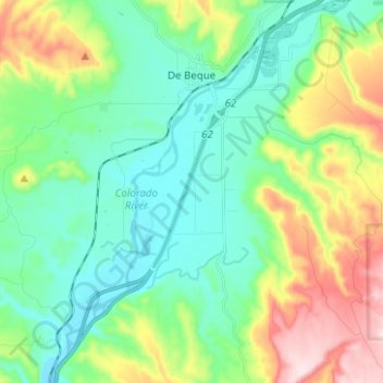
Naam: Topografische kaart De Beque, hoogte, reliëf.
Locatie: De Beque, Mesa County, Colorado, United States (39.25691 -108.22222 39.35346 -108.16632)
Gemiddelde hoogte: 1.597 m
Minimale hoogte: 1.476 m
Maximale hoogte: 1.889 m
Andere topografische kaarten
Klik op een kaart om zijn topografie, zijn hoogte en zijn reliëf te bekijken.
Fruita
United States > Colorado > Mesa County
The original town site was planned for 80 acres (32 ha) with a park in the middle. The first water reached the town from the Colorado River in 1907. By 1909, the town center was linked with electricity. In the 1930s, Fruita participated in several government projects, including the Grand Valley Resettlement…
Gemiddelde hoogte: 1.400 m
Grand Mesa
United States > Colorado > Mesa County
The Grand Mesa is a large mesa in western Colorado in the United States. It is the largest flat-topped mountain in the world. It has an area of about 500 square miles (1,300 km2) and stretches for about 40 miles (60 km) east of Grand Junction between the Colorado River and the Gunnison River, its tributary to…
Gemiddelde hoogte: 2.666 m
Grand Mesa
United States > Colorado > Mesa County
The Grand Mesa is a large mesa in western Colorado in the United States. It is the largest flat-topped mountain in the world. It has an area of about 500 square miles (1,300 km2) and stretches for about 40 miles (64 km) east of Grand Junction between the Colorado River and the Gunnison River, its tributary to…
Gemiddelde hoogte: 2.666 m
Fruita
United States > Colorado > Mesa County
The original town site was planned for 80 acres (32 ha) with a park in the middle. The first water reached the town from the Colorado River in 1907. By 1909, the town center was linked with electricity. In the 1930s, Fruita participated in several government projects, including the Grand Valley Resettlement…
Gemiddelde hoogte: 1.400 m
Colorado National Monument
United States > Colorado > Mesa County > Grand Junction
Gemiddelde hoogte: 1.809 m