
Topografische kaart Collbran
Klik op de kaart om de hoogte weer te geven.
Over deze kaart
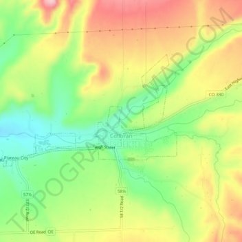
Naam: Topografische kaart Collbran, hoogte, reliëf.
Locatie: Collbran, Mesa County, Colorado, United States (39.23259 -107.99765 39.25288 -107.95030)
Gemiddelde hoogte: 1.882 m
Minimale hoogte: 1.788 m
Maximale hoogte: 1.987 m
Andere topografische kaarten
Klik op een kaart om zijn topografie, zijn hoogte en zijn reliëf te bekijken.
Grand Mesa
United States > Colorado > Mesa County
The Grand Mesa is a large mesa in western Colorado in the United States. It is the largest flat-topped mountain in the world. It has an area of about 500 square miles (1,300 km2) and stretches for about 40 miles (60 km) east of Grand Junction between the Colorado River and the Gunnison River, its tributary to…
Gemiddelde hoogte: 2.666 m
Colorado River
United States > Colorado > Mesa County > Clifton
The entire eastern boundary of the Colorado River Basin runs along the North American Continental Divide and is defined largely by the Rocky Mountains and the Rio Grande Basin. The Wind River Range in Wyoming marks the northern extent of the basin, and is separated from the Colorado Rockies by the endorheic…
Gemiddelde hoogte: 1.417 m
Grand Mesa
United States > Colorado > Mesa County
The Grand Mesa is a large mesa in western Colorado in the United States. It is the largest flat-topped mountain in the world. It has an area of about 500 square miles (1,300 km2) and stretches for about 40 miles (64 km) east of Grand Junction between the Colorado River and the Gunnison River, its tributary to…
Gemiddelde hoogte: 2.666 m
Colorado River
United States > Colorado > Mesa County
The entire eastern boundary of the Colorado River Basin runs along the North American Continental Divide and is defined largely by the Rocky Mountains and the Rio Grande Basin. The Wind River Range in Wyoming marks the northern extent of the basin, and is separated from the Colorado Rockies by the endorheic…
Gemiddelde hoogte: 1.417 m