
Topografische kaart New Baltimore
Klik op de kaart om de hoogte weer te geven.
Over deze kaart
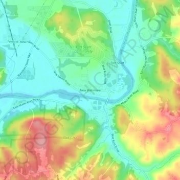
Naam: Topografische kaart New Baltimore, hoogte, reliëf.
Gemiddelde hoogte: 195 m
Minimale hoogte: 150 m
Maximale hoogte: 270 m
Andere topografische kaarten
Klik op een kaart om zijn topografie, zijn hoogte en zijn reliëf te bekijken.
Cincinnati
United States > Ohio > Hamilton County
Cincinnati has several standard modes of transportation including sidewalks, roads, public transit, bicycle paths and airports. The city's hills preclude the regular street grid common to many cities built up in the 19th century, and outside of the downtown basin, regular street grids are rare except for in…
Gemiddelde hoogte: 222 m
Cincinnati
United States > Ohio > Hamilton County
Cincinnati features a distinctive topography characterized by its rolling hills and valleys. The city is situated on the north bank of the Ohio River, where the terrain rises sharply from the riverfront, reaching elevations of approximately 980 feet (299 meters) in some areas. The average elevation throughout…
Gemiddelde hoogte: 222 m
Norwood
United States > Ohio > Hamilton County
The earliest humans in the area now known as Norwood are believed to have been Pre-Columbian era people of the Adena culture. Norwood Mound, a prehistoric earthwork mound built by the Adena, is located in Norwood and listed on the National Register of Historic Places. The Adena constructed the mound at the…
Gemiddelde hoogte: 196 m
Loveland
United States > Ohio > Hamilton County
According to the United States Census Bureau, the city has a total area of 5.00 square miles (12.95 km2), of which 4.93 square miles (12.77 km2) is land and 0.07 square miles (0.18 km2) is water. The city is situated at an elevation of 597 ft (182 m) above sea level.
Gemiddelde hoogte: 222 m
Nature Center at The Summit
United States > Ohio > Hamilton County > Cincinnati
Gemiddelde hoogte: 173 m
Covedale Gardens
United States > Ohio > Hamilton County > Cincinnati > Covedale
Gemiddelde hoogte: 268 m
Loveland
United States > Ohio > Hamilton County
According to the United States Census Bureau, the city has a total area of 5.00 square miles (12.95 km2), of which 4.93 square miles (12.77 km2) is land and 0.07 square miles (0.18 km2) is water. The city is situated at an elevation of 597 ft (182 m) above sea level.
Gemiddelde hoogte: 222 m
Nature Center at The Summit
United States > Ohio > Hamilton County > Cincinnati
Gemiddelde hoogte: 173 m
Cincinnati
United States > Ohio > Hamilton County
Cincinnati has several standard modes of transportation including sidewalks, roads, public transit, bicycle paths and airports. The city's hills preclude the regular street grid common to many cities built up in the 19th century, and outside of the downtown basin, regular street grids are rare except for in…
Gemiddelde hoogte: 222 m
Camp John McLean Memorial Park
United States > Ohio > Hamilton County > Wyoming > Park Place
Gemiddelde hoogte: 207 m
Cincinnati
United States > Ohio > Hamilton County
Cincinnati has several standard modes of transportation including sidewalks, roads, public transit, bicycle paths and airports. The city's hills preclude the regular street grid common to many cities built up in the 19th century, and outside of the downtown basin, regular street grids are rare except for in…
Gemiddelde hoogte: 222 m
French Park
United States > Ohio > Hamilton County > Amberley Village > Rolling Knolls Estate
Gemiddelde hoogte: 235 m
Norwood
United States > Ohio > Hamilton County
The earliest humans in the area now known as Norwood are believed to have been Pre-Columbian era people of the Adena culture. Norwood Mound, a prehistoric earthwork mound built by the Adena, is located in Norwood and listed on the National Register of Historic Places. The Adena constructed the mound at the…
Gemiddelde hoogte: 196 m
Cincinnati
United States > Ohio > Hamilton County
Cincinnati has several standard modes of transportation including sidewalks, roads, public transit, bicycle paths and airports. The city's hills preclude the regular street grid common to many cities built up in the 19th century, and outside of the downtown basin, regular street grids are rare except for in…
Gemiddelde hoogte: 222 m