
Topografische kaart Saint Bernard
Klik op de kaart om de hoogte weer te geven.
Over deze kaart
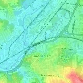
Naam: Topografische kaart Saint Bernard, hoogte, reliëf.
Locatie: Saint Bernard, Hamilton County, Ohio, 45217, United States (39.16008 -84.50749 39.18336 -84.48296)
Gemiddelde hoogte: 168 m
Minimale hoogte: 147 m
Maximale hoogte: 227 m
Andere topografische kaarten
Klik op een kaart om zijn topografie, zijn hoogte en zijn reliëf te bekijken.
Nature Center at The Summit
United States > Ohio > Hamilton County > Cincinnati
Gemiddelde hoogte: 173 m
Covedale Gardens
United States > Ohio > Hamilton County > Cincinnati > Covedale
Gemiddelde hoogte: 268 m
Cincinnati
United States > Ohio > Hamilton County
Cincinnati has several standard modes of transportation including sidewalks, roads, public transit, bicycle paths and airports. The city's hills preclude the regular street grid common to many cities built up in the 19th century, and outside of the downtown basin, regular street grids are rare except for in…
Gemiddelde hoogte: 225 m
Nature Center at The Summit
United States > Ohio > Hamilton County > Cincinnati
Gemiddelde hoogte: 173 m
Camp John McLean Memorial Park
United States > Ohio > Hamilton County > Wyoming > Park Place
Gemiddelde hoogte: 207 m
French Park
United States > Ohio > Hamilton County > Amberley Village > Rolling Knolls Estate
Gemiddelde hoogte: 235 m