
Topografische kaart Cincinnati
Klik op de kaart om de hoogte weer te geven.
Cincinnati
Cincinnati features a distinctive topography characterized by its rolling hills and valleys. The city is situated on the north bank of the Ohio River, where the terrain rises sharply from the riverfront, reaching elevations of approximately 980 feet (299 meters) in some areas. The average elevation throughout Cincinnati is around 735 feet (224 meters), though it varies considerably, with notable hills such as Mount Adams and Mount Lookout contributing to a landscape that lacks the regular street grid found in many other urban areas. This undulating terrain, coupled with the river's influence, has shaped the city's development and provides scenic views, particularly from elevated locations.
Over deze kaart
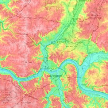
Naam: Topografische kaart Cincinnati, hoogte, reliëf.
Locatie: Cincinnati, Hamilton County, Ohio, United States (39.05206 -84.71239 39.22104 -84.36958)
Gemiddelde hoogte: 222 m
Minimale hoogte: 139 m
Maximale hoogte: 293 m
Andere topografische kaarten
Klik op een kaart om zijn topografie, zijn hoogte en zijn reliëf te bekijken.
Nature Center at The Summit
United States > Ohio > Hamilton County > Cincinnati
Gemiddelde hoogte: 173 m
Covedale Gardens
United States > Ohio > Hamilton County > Cincinnati > Covedale
Gemiddelde hoogte: 268 m
Cincinnati
United States > Ohio > Hamilton County
Cincinnati has several standard modes of transportation including sidewalks, roads, public transit, bicycle paths and airports. The city's hills preclude the regular street grid common to many cities built up in the 19th century, and outside of the downtown basin, regular street grids are rare except for in…
Gemiddelde hoogte: 225 m
Nature Center at The Summit
United States > Ohio > Hamilton County > Cincinnati
Gemiddelde hoogte: 173 m
Camp John McLean Memorial Park
United States > Ohio > Hamilton County > Wyoming > Park Place
Gemiddelde hoogte: 207 m
French Park
United States > Ohio > Hamilton County > Amberley Village > Rolling Knolls Estate
Gemiddelde hoogte: 235 m