
Doe een donatie
Rust jezelf uit voor je volgende avontuur:
Als Amazon-partner verdient deze site een commissie op in aanmerking komende aankopen, zonder extra kosten voor jou.
Topografische kaart Hyndman Peak
Klik op de kaart om de hoogte weer te geven.
Doe een donatie
Rust jezelf uit voor je volgende avontuur:
Als Amazon-partner verdient deze site een commissie op in aanmerking komende aankopen, zonder extra kosten voor jou.
Hyndman Peak
Hyndman Peak, at an elevation of 12,012 feet (3,661 m) above sea level, is the ninth highest peak in Idaho and the highest point in the Pioneer Mountains, Sawtooth National Forest, and Blaine County. Hyndman Peak is located on the border of Custer and Blaine counties. The towns of Hailey, Ketchum, and Sun Valley are west of the peak.
Doe een donatie
Rust jezelf uit voor je volgende avontuur:
Als Amazon-partner verdient deze site een commissie op in aanmerking komende aankopen, zonder extra kosten voor jou.
Over deze kaart
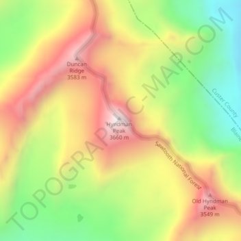
Naam: Topografische kaart Hyndman Peak, hoogte, reliëf.
Locatie: Hyndman Peak, Blaine County, Idaho, United States (43.74932 -114.13113 43.74942 -114.13103)
Gemiddelde hoogte: 3.170 m
Minimale hoogte: 2.708 m
Maximale hoogte: 3.645 m
Doe een donatie
Rust jezelf uit voor je volgende avontuur:
Als Amazon-partner verdient deze site een commissie op in aanmerking komende aankopen, zonder extra kosten voor jou.
Andere topografische kaarten
Klik op een kaart om zijn topografie, zijn hoogte en zijn reliëf te bekijken.
Sun Valley
United States > Idaho > Blaine County
Sun Valley is a resort city in the western United States, in Blaine County, Idaho, adjacent to the city of Ketchum in the Wood River valley. The population was 1406 at the 2010 census, down from 1427 in 2000. The elevation of Sun Valley (at the Lodge) is 5,920 feet (1,805 m) above sea level.
Gemiddelde hoogte: 1.988 m
Ketchum
United States > Idaho > Blaine County
After the mining boom subsided in the 1890s, sheepmen from the south drove their flocks north through Ketchum in the summer, to graze in the upper elevation areas of the Pioneer, Boulder, and Sawtooth mountains. By 1920, Ketchum had become the largest sheep-shipping center in the West. In the fall, massive…
Gemiddelde hoogte: 1.906 m
Alice Lake
United States > Idaho > Blaine County
The direct route to the lake begins at the trailhead at the end of the Pettit Lake campground. The trail distance is about 5.5 mi (9 km) to the lake and gains about 1,600 feet (490 m) in elevation. The trail requires five stream crossings, only the last of which has a bridge.
Gemiddelde hoogte: 2.747 m
Doe een donatie
Rust jezelf uit voor je volgende avontuur:
Als Amazon-partner verdient deze site een commissie op in aanmerking komende aankopen, zonder extra kosten voor jou.
Sun Valley
United States > Idaho > Blaine County
Sun Valley is a resort city in the western United States, in Blaine County, Idaho, adjacent to the city of Ketchum in the Wood River valley. The population was 1,783 at the 2020 census. The elevation of Sun Valley (at the Lodge) is 5,920 feet (1,805 m) above sea level.
Gemiddelde hoogte: 1.988 m
Doe een donatie
Rust jezelf uit voor je volgende avontuur:
Als Amazon-partner verdient deze site een commissie op in aanmerking komende aankopen, zonder extra kosten voor jou.
Sun Valley
United States > Idaho > Blaine County
Sun Valley is a resort city in the western United States, in Blaine County, Idaho, adjacent to the city of Ketchum in the Wood River valley. The population was 1,783 at the 2020 census. The elevation of Sun Valley (at the Lodge) is 5,920 feet (1,805 m) above sea level.
Gemiddelde hoogte: 1.988 m
Hailey
United States > Idaho > Blaine County
Hailey is located at 43°30′54″N 114°18′23″W / 43.51500°N 114.30639°W / 43.51500; -114.30639 (43.514937, -114.306251), at an elevation of 5,318 feet (1,621 m) above sea level.
Gemiddelde hoogte: 1.729 m
Ketchum
United States > Idaho > Blaine County
After the mining boom subsided in the 1890s, sheepmen from the south drove their flocks north through Ketchum in the summer, to graze in the upper elevation areas of the Pioneer, Boulder, and Sawtooth mountains. By 1920, Ketchum had become the largest sheep-shipping center in the West. In the fall, massive…
Gemiddelde hoogte: 1.906 m