
Doe een donatie
Rust jezelf uit voor je volgende avontuur:
Als Amazon-partner verdient deze site een commissie op in aanmerking komende aankopen, zonder extra kosten voor jou.
Topografische kaart Sun Valley
Klik op de kaart om de hoogte weer te geven.
Doe een donatie
Rust jezelf uit voor je volgende avontuur:
Als Amazon-partner verdient deze site een commissie op in aanmerking komende aankopen, zonder extra kosten voor jou.
Sun Valley
Sun Valley is a resort city in the western United States, in Blaine County, Idaho, adjacent to the city of Ketchum in the Wood River valley. The population was 1406 at the 2010 census, down from 1427 in 2000. The elevation of Sun Valley (at the Lodge) is 5,920 feet (1,805 m) above sea level.
Doe een donatie
Rust jezelf uit voor je volgende avontuur:
Als Amazon-partner verdient deze site een commissie op in aanmerking komende aankopen, zonder extra kosten voor jou.
Over deze kaart
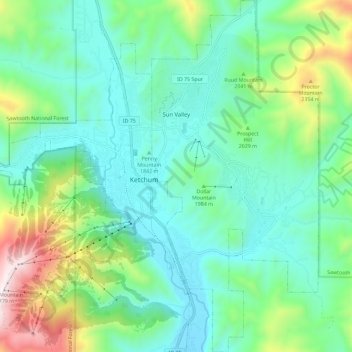
Naam: Topografische kaart Sun Valley, hoogte, reliëf.
Locatie: Sun Valley, Blaine County, Idaho, United States (43.63996 -114.36125 43.72314 -114.30661)
Gemiddelde hoogte: 1.988 m
Minimale hoogte: 1.724 m
Maximale hoogte: 2.780 m
Doe een donatie
Rust jezelf uit voor je volgende avontuur:
Als Amazon-partner verdient deze site een commissie op in aanmerking komende aankopen, zonder extra kosten voor jou.
Andere topografische kaarten
Klik op een kaart om zijn topografie, zijn hoogte en zijn reliëf te bekijken.
Hyndman Peak
United States > Idaho > Blaine County
Hyndman Peak, at an elevation of 12,012 feet (3,661 m) above sea level, is the ninth highest peak in Idaho and the highest point in the Pioneer Mountains, Sawtooth National Forest, and Blaine County. Hyndman Peak is located on the border of Custer and Blaine counties. The towns of Hailey, Ketchum, and Sun…
Gemiddelde hoogte: 3.170 m