
Doe een donatie
Rust jezelf uit voor je volgende avontuur:
Als Amazon-partner verdient deze site een commissie op in aanmerking komende aankopen, zonder extra kosten voor jou.
Topografische kaart Ketchum
Klik op de kaart om de hoogte weer te geven.
Doe een donatie
Rust jezelf uit voor je volgende avontuur:
Als Amazon-partner verdient deze site een commissie op in aanmerking komende aankopen, zonder extra kosten voor jou.
Ketchum
After the mining boom subsided in the 1890s, sheepmen from the south drove their flocks north through Ketchum in the summer, to graze in the upper elevation areas of the Pioneer, Boulder, and Sawtooth mountains. By 1920, Ketchum had become the largest sheep-shipping center in the West. In the fall, massive flocks of sheep flowed south into the town's livestock corrals at the Union Pacific Railroad's railhead, which connected to the main line at Shoshone.
Doe een donatie
Rust jezelf uit voor je volgende avontuur:
Als Amazon-partner verdient deze site een commissie op in aanmerking komende aankopen, zonder extra kosten voor jou.
Over deze kaart
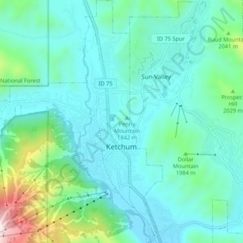
Naam: Topografische kaart Ketchum, hoogte, reliëf.
Locatie: Ketchum, Blaine County, Idaho, United States (43.65955 -114.41189 43.71297 -114.35118)
Gemiddelde hoogte: 1.906 m
Minimale hoogte: 1.742 m
Maximale hoogte: 2.671 m
Doe een donatie
Rust jezelf uit voor je volgende avontuur:
Als Amazon-partner verdient deze site een commissie op in aanmerking komende aankopen, zonder extra kosten voor jou.
Andere topografische kaarten
Klik op een kaart om zijn topografie, zijn hoogte en zijn reliëf te bekijken.
Hyndman Peak
United States > Idaho > Blaine County
Hyndman Peak, at an elevation of 12,012 feet (3,661 m) above sea level, is the ninth highest peak in Idaho and the highest point in the Pioneer Mountains, Sawtooth National Forest, and Blaine County. Hyndman Peak is located on the border of Custer and Blaine counties. The towns of Hailey, Ketchum, and Sun…
Gemiddelde hoogte: 3.170 m