
Topografische kaart McKinney Creek
Interactieve kaart
Klik op de kaart om de hoogte weer te geven.
Over deze kaart
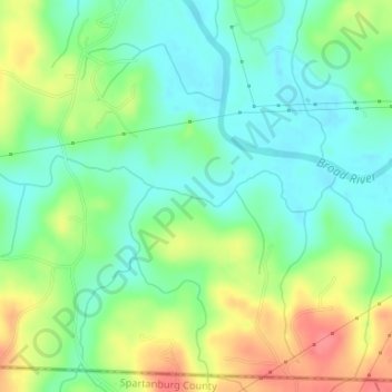
Naam: Topografische kaart McKinney Creek, hoogte, reliëf.
Gemiddelde hoogte: 233 m
Minimale hoogte: 208 m
Maximale hoogte: 275 m
Andere topografische kaarten
Klik op een kaart om zijn topografie, zijn hoogte en zijn reliëf te bekijken.
Emerald Isle
USA > North Carolina > Emerald Isle
Emerald Isle, Carteret County, North Carolina, 28594, USA
Gemiddelde hoogte: 1 m
Cramerton
USA > North Carolina > Cramerton
Cramerton, Gaston County, North Carolina, 28032, USA
Gemiddelde hoogte: 202 m
Salisbury
USA > North Carolina > Salisbury
Salisbury, Rowan County, North Carolina, USA
Gemiddelde hoogte: 224 m
Tobermory
USA > North Carolina > Tobermory
Tobermory, Bladen County, North Carolina, USA
Gemiddelde hoogte: 44 m
Delta
USA > North Carolina > Delta
Delta, Stokes County, North Carolina, 27046, USA
Gemiddelde hoogte: 315 m
Carmen
USA > North Carolina > Carmen
Carmen, Madison County, North Carolina, USA
Gemiddelde hoogte: 846 m
Chapel Hill
USA > North Carolina > Chapel Hill
Chapel Hill, Orange County, North Carolina, USA
Gemiddelde hoogte: 125 m
Wilkins Creek
Wilkins Creek, Haywood County, North Carolina, USA
Gemiddelde hoogte: 795 m
Drinkwater Creek
Drinkwater Creek, Beaufort County, North Carolina, 27806, USA
Gemiddelde hoogte: 3 m
Garrison Creek
Garrison Creek, Burke County, North Carolina, USA
Gemiddelde hoogte: 425 m
Thompson River
Thompson River, Transylvania County, North Carolina, USA
Gemiddelde hoogte: 654 m
Shepherd Creek
Shepherd Creek, Macon County, North Carolina, USA
Gemiddelde hoogte: 744 m
Mount Mitchell
Mount Mitchell, Yancey County, North Carolina, USA
Gemiddelde hoogte: 1.743 m
Jack Creek
Jack Creek, Beaufort County, North Carolina, 27814, USA
Gemiddelde hoogte: 6 m
Southern Nantahala Wilderness
Southern Nantahala Wilderness, Appalachian Trail, Macon County, North Carolina, USA
Gemiddelde hoogte: 957 m
Skunk Creek
USA > North Carolina > Sanford
Skunk Creek, Sanford, Lee County, North Carolina, 27339, USA
Gemiddelde hoogte: 112 m
Downs Mountain
Downs Mountain, Macon County, North Carolina, 28763, USA
Gemiddelde hoogte: 732 m
Dog Mountain
Dog Mountain, Macon County, North Carolina, 28741, USA
Gemiddelde hoogte: 1.168 m
Mayo Reservoir
USA > North Carolina > Triple Springs
Mayo Reservoir, Creek Mayo Road, Triple Springs, Person County, North Carolina, USA
Gemiddelde hoogte: 155 m
Lincolnton
USA > North Carolina > Lincolnton
Lincolnton, Lincoln County, North Carolina, 28092, USA
Gemiddelde hoogte: 260 m
Bear Paw State Natural Area
USA > North Carolina > Valley Creek
Bear Paw State Natural Area, Valley Creek, Watauga County, North Carolina, USA
Gemiddelde hoogte: 1.249 m
Fishing Branch
Fishing Branch, Person County, North Carolina, USA
Gemiddelde hoogte: 156 m
Mitchell River
Mitchell River, Surry County, North Carolina, USA
Gemiddelde hoogte: 415 m
Cedar Hill
USA > North Carolina > Cedar Hill
Cedar Hill, Anson County, North Carolina, USA
Gemiddelde hoogte: 95 m
Foster Creek
Foster Creek, Madison County, North Carolina, USA
Gemiddelde hoogte: 939 m
Dudley Shoals
USA > North Carolina > Dudley Shoals
Dudley Shoals, Caldwell County, North Carolina, USA
Gemiddelde hoogte: 353 m
Rabbitskin Branch
Rabbitskin Branch, Haywood County, North Carolina, 28785, USA
Gemiddelde hoogte: 830 m
Carolina Trace
USA > North Carolina > Carolina Trace
Carolina Trace, Lee County, North Carolina, 27732, USA
Gemiddelde hoogte: 101 m
Ivy Ridge
USA > North Carolina > Ivy Ridge
Ivy Ridge, Madison County, North Carolina, USA
Gemiddelde hoogte: 948 m
Brushy Creek
Brushy Creek, Rockingham County, North Carolina, USA
Gemiddelde hoogte: 208 m
Robertson Creek
Robertson Creek, Granville County, North Carolina, USA
Gemiddelde hoogte: 116 m
Big Muddy Creek
Big Muddy Creek, Scotland County, North Carolina, USA
Gemiddelde hoogte: 95 m
Mosley Creek
Mosley Creek, Lenoir County, North Carolina, 28526, USA
Gemiddelde hoogte: 12 m
Slim Creek
Slim Creek, McDowell County, North Carolina, USA
Gemiddelde hoogte: 711 m