Geolokaliseren

Topografische kaart Breckenridge

Klik op de kaart om de hoogte weer te geven.

Breckenridge

At the 2020 United States Census, the town had a total area of 6.047 square miles (15.661 km2), all of it land. The ski area has a total area of 2,880 acres (11.7 km2) of land. The elevation of Breckenridge is 9,600 feet (2,900 m) above sea level.

Wikipedia (CC-BY-SA 3.0)

Over deze kaart

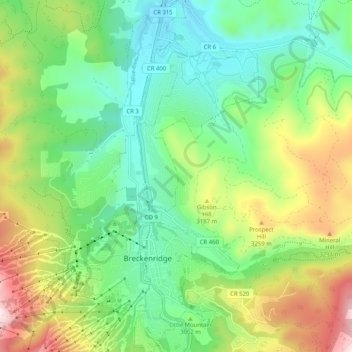
Naam: Topografische kaart Breckenridge, hoogte, reliëf.

Locatie: Breckenridge, Summit County, Colorado, United States (39.46183 -106.07203 39.54046 -106.01439)

Gemiddelde hoogte: 3.072 m

Minimale hoogte: 2.802 m

Maximale hoogte: 3.809 m

👉 Easily get elevation data in JSON, GeoTIFF and KML formats using Elevation API
Bedankt voor het steunen van deze site ❤️
Doe een donatie

Rust jezelf uit voor je volgende avontuur:

Als Amazon-partner verdient deze site een commissie op in aanmerking komende aankopen, zonder extra kosten voor jou.

Andere topografische kaarten

Klik op een kaart om zijn topografie, zijn hoogte en zijn reliëf te bekijken.

Argentine Pass

United States > Colorado > Summit County

Argentine Pass, elevation 13,207 ft (4,025 m), is a high mountain pass that crosses the Continental Divide in the Front Range of the Rocky Mountains of central Colorado in the United States. Argentine Pass is located on the crest of the Front Range along the boundary southwest of Georgetown and is the highest…

Gemiddelde hoogte: 3.797 m

Mount Guyot

United States > Colorado > Summit County

Gemiddelde hoogte: 3.601 m

Quandary Peak

United States > Colorado > Summit County

Quandary Peak is the highest summit of the Tenmile Range in the Rocky Mountains of North America at 14,271 ft (4,350 m). As of 2018, it was the most commonly climbed fourteener in Colorado. It has nearly the same elevation as Castle Peak and Mount Blue Sky. It lies in Summit County and within the White River…

Gemiddelde hoogte: 3.833 m

Chief Mountain

United States > Colorado > Summit County

Gemiddelde hoogte: 3.367 m

Silverthorne

United States > Colorado > Summit County

Gemiddelde hoogte: 2.858 m

Decatur Mountain

United States > Colorado > Summit County

Gemiddelde hoogte: 3.661 m

Bald Mountain

United States > Colorado > Summit County

Gemiddelde hoogte: 3.733 m

Dillon

United States > Colorado > Summit County > Silverthorne

Gemiddelde hoogte: 2.796 m

Bedankt voor het steunen van deze site ❤️
Doe een donatie

Rust jezelf uit voor je volgende avontuur:

Als Amazon-partner verdient deze site een commissie op in aanmerking komende aankopen, zonder extra kosten voor jou.

Rust jezelf uit voor je volgende avontuur:

🧭Survival Uitrusting - Essentiële tools voor noodsituaties
Sporthorloges met GPS - Track je route, hoogteverschillen en hartslag
🪑Picknickdekens - Comfortabel zitten op gras of zand
🥤Outdoor Drinkflessen - Herbruikbare flessen voor lange wandelingen
🎒Dagrugzakken - Compacte rugzakken voor korte wandelingen

Als Amazon-partner verdient deze site een commissie op in aanmerking komende aankopen, zonder extra kosten voor jou.