
Topografische kaart Decatur Mountain
Klik op de kaart om de hoogte weer te geven.
Over deze kaart
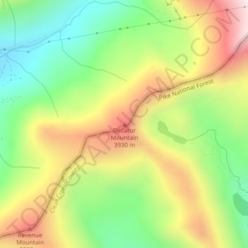
Naam: Topografische kaart Decatur Mountain, hoogte, reliëf.
Locatie: Decatur Mountain, Summit County, Colorado, United States (39.59466 -105.79506 39.59476 -105.79496)
Gemiddelde hoogte: 3.661 m
Minimale hoogte: 3.318 m
Maximale hoogte: 4.089 m
Andere topografische kaarten
Klik op een kaart om zijn topografie, zijn hoogte en zijn reliëf te bekijken.
Breckenridge
United States > Colorado > Summit County
At the 2020 United States Census, the town had a total area of 6.047 square miles (15.661 km2), all of it land. The ski area has a total area of 2,880 acres (11.7 km2) of land. The elevation of Breckenridge is 9,600 feet (2,900 m) above sea level.
Gemiddelde hoogte: 3.072 m
Montezuma
United States > Colorado > Summit County
The Town of Montezuma is a statutory town located in eastern Summit County, Colorado, United States. The town population was 74 at 2020 United States census. The town is a former mining camp that sits at an elevation of 10,200 feet (3,110 m), just west of the Continental Divide, nestled among mountains that…
Gemiddelde hoogte: 3.307 m
Breckenridge
United States > Colorado > Summit County
At the 2020 United States Census, the town had a total area of 6.047 square miles (15.661 km2), all of it land. The ski area has a total area of 2,880 acres (11.7 km2) of land. The elevation of Breckenridge is 9,600 feet (2,900 m) above sea level.
Gemiddelde hoogte: 3.072 m
Breckenridge
United States > Colorado > Summit County
At the 2020 United States census, the town had a total area of 6.047 square miles (15.661 km2), all of it land. The ski area has a total area of 2,880 acres (11.7 km2) of land. The elevation of Breckenridge is 9,601 feet (2,926 m) above sea level.
Gemiddelde hoogte: 3.072 m
Dillon
United States > Colorado > Summit County
During the Great Depression, Denver Water began acquiring land around Dillon. In 1956, residents and business owners in Dillon were notified that they would need to sell their property and move out, because Denver Water was about to begin construction on a dam just downstream from the town, and the resulting…
Gemiddelde hoogte: 2.796 m