
Doe een donatie
Rust jezelf uit voor je volgende avontuur:
Als Amazon-partner verdient deze site een commissie op in aanmerking komende aankopen, zonder extra kosten voor jou.
Topografische kaart Quandary Peak
Klik op de kaart om de hoogte weer te geven.
Doe een donatie
Rust jezelf uit voor je volgende avontuur:
Als Amazon-partner verdient deze site een commissie op in aanmerking komende aankopen, zonder extra kosten voor jou.
Quandary Peak
Quandary Peak is the highest summit of the Tenmile Range in the Rocky Mountains of North America at 14,271 ft (4,350 m). As of 2018, it was the most commonly climbed fourteener in Colorado. It has nearly the same elevation as Castle Peak and Mount Blue Sky. It lies in Summit County and within the White River National Forest about 6 miles (10 km) south-southwest of the town of Breckenridge.
Doe een donatie
Rust jezelf uit voor je volgende avontuur:
Als Amazon-partner verdient deze site een commissie op in aanmerking komende aankopen, zonder extra kosten voor jou.
Over deze kaart
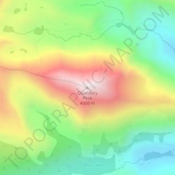
Naam: Topografische kaart Quandary Peak, hoogte, reliëf.
Locatie: Quandary Peak, Summit County, Colorado, United States (39.39724 -106.10648 39.39734 -106.10638)
Gemiddelde hoogte: 3.833 m
Minimale hoogte: 3.466 m
Maximale hoogte: 4.343 m
Doe een donatie
Rust jezelf uit voor je volgende avontuur:
Als Amazon-partner verdient deze site een commissie op in aanmerking komende aankopen, zonder extra kosten voor jou.
Andere topografische kaarten
Klik op een kaart om zijn topografie, zijn hoogte en zijn reliëf te bekijken.
Breckenridge
United States > Colorado > Summit County
At the 2020 United States Census, the town had a total area of 6.047 square miles (15.661 km2), all of it land. The ski area has a total area of 2,880 acres (11.7 km2) of land. The elevation of Breckenridge is 9,600 feet (2,900 m) above sea level.
Gemiddelde hoogte: 3.072 m
Doe een donatie
Rust jezelf uit voor je volgende avontuur:
Als Amazon-partner verdient deze site een commissie op in aanmerking komende aankopen, zonder extra kosten voor jou.
Montezuma
United States > Colorado > Summit County
The Town of Montezuma is a statutory town located in eastern Summit County, Colorado, United States. The town population was 74 at 2020 United States census. The town is a former mining camp that sits at an elevation of 10,200 feet (3,110 m), just west of the Continental Divide, nestled among mountains that…
Gemiddelde hoogte: 3.307 m
Breckenridge
United States > Colorado > Summit County
At the 2020 United States Census, the town had a total area of 6.047 square miles (15.661 km2), all of it land. The ski area has a total area of 2,880 acres (11.7 km2) of land. The elevation of Breckenridge is 9,600 feet (2,900 m) above sea level.
Gemiddelde hoogte: 3.072 m
Doe een donatie
Rust jezelf uit voor je volgende avontuur:
Als Amazon-partner verdient deze site een commissie op in aanmerking komende aankopen, zonder extra kosten voor jou.
Breckenridge
United States > Colorado > Summit County
At the 2020 United States census, the town had a total area of 6.047 square miles (15.661 km2), all of it land. The ski area has a total area of 2,880 acres (11.7 km2) of land. The elevation of Breckenridge is 9,601 feet (2,926 m) above sea level.
Gemiddelde hoogte: 3.072 m
Doe een donatie
Rust jezelf uit voor je volgende avontuur:
Als Amazon-partner verdient deze site een commissie op in aanmerking komende aankopen, zonder extra kosten voor jou.
Dillon
United States > Colorado > Summit County
During the Great Depression, Denver Water began acquiring land around Dillon. In 1956, residents and business owners in Dillon were notified that they would need to sell their property and move out, because Denver Water was about to begin construction on a dam just downstream from the town, and the resulting…
Gemiddelde hoogte: 2.796 m
Doe een donatie
Rust jezelf uit voor je volgende avontuur:
Als Amazon-partner verdient deze site een commissie op in aanmerking komende aankopen, zonder extra kosten voor jou.