
Topografische kaart Eskdalemuir
Interactieve kaart
Klik op de kaart om de hoogte weer te geven.
Over deze kaart
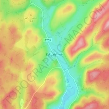
Naam: Topografische kaart Eskdalemuir, hoogte, reliëf.
Gemiddelde hoogte: 246 m
Minimale hoogte: 175 m
Maximale hoogte: 319 m
In spite of it being located inland, the dull and wet nature of the climate due to the elevation leads to chilly summers that are colder than more northerly locations such as Glasgow and Edinburgh. The inland nature of the climate is more manifest during winter months with frosts being common, and the average lows between December and February are below the freezing point.
Andere topografische kaarten
Klik op een kaart om zijn topografie, zijn hoogte en zijn reliëf te bekijken.
Fingland
United Kingdom > Scotland > Dumfries and Galloway
Fingland, Dumfries and Galloway, Scotland, DG11 2LD, United Kingdom
Gemiddelde hoogte: 206 m
Durisdeer
United Kingdom > Scotland > Dumfries and Galloway
Durisdeer, Dumfries and Galloway, Scotland, DG3 5BJ, United Kingdom
Gemiddelde hoogte: 270 m
Moniaive
United Kingdom > Scotland > Dumfries and Galloway
Moniaive, Dumfries and Galloway, Scotland, DG3 4HN, United Kingdom
Gemiddelde hoogte: 179 m
Doons
United Kingdom > Scotland > Dumfries and Galloway
Doons, Dumfries and Galloway, Scotland, DG3 4NG, United Kingdom
Gemiddelde hoogte: 202 m