
Topografische kaart Durisdeer
Interactieve kaart
Klik op de kaart om de hoogte weer te geven.
Over deze kaart
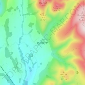
Naam: Topografische kaart Durisdeer, hoogte, reliëf.
Gemiddelde hoogte: 270 m
Minimale hoogte: 112 m
Maximale hoogte: 589 m
Andere topografische kaarten
Klik op een kaart om zijn topografie, zijn hoogte en zijn reliëf te bekijken.
Fingland
United Kingdom > Scotland > Dumfries and Galloway
Fingland, Dumfries and Galloway, Scotland, DG11 2LD, United Kingdom
Gemiddelde hoogte: 206 m
Eskdalemuir
United Kingdom > Scotland > Dumfries and Galloway
Eskdalemuir, Dumfries and Galloway, Scotland, DG13 0QF, United Kingdom
Gemiddelde hoogte: 246 m
Moniaive
United Kingdom > Scotland > Dumfries and Galloway
Moniaive, Dumfries and Galloway, Scotland, DG3 4HN, United Kingdom
Gemiddelde hoogte: 179 m
Doons
United Kingdom > Scotland > Dumfries and Galloway
Doons, Dumfries and Galloway, Scotland, DG3 4NG, United Kingdom
Gemiddelde hoogte: 202 m