
Topografische kaart County Limerick
Interactieve kaart
Klik op de kaart om de hoogte weer te geven.
Over deze kaart
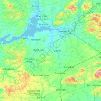
Naam: Topografische kaart County Limerick, hoogte, reliëf.
Locatie: County Limerick, Munster, Irland (52.28020 -9.36543 52.75738 -8.15639)
Gemiddelde hoogte: 110 m
Minimale hoogte: -1 m
Maximale hoogte: 811 m
Andere topografische kaarten
Klik op een kaart om zijn topografie, zijn hoogte en zijn reliëf te bekijken.
Abbeyfeale
Irland > County Limerick > The Municipal District of Newcastle West
Abbeyfeale, The Municipal District of Newcastle West, County Limerick, Munster, Irland
Gemiddelde hoogte: 150 m
Abbeyfeale
Irland > County Limerick > The Municipal District of Newcastle West > Abbeyfeale
Abbeyfeale, The Municipal District of Newcastle West, County Limerick, Munster, Irland
Gemiddelde hoogte: 122 m