
Topografische kaart Limerick
Interactieve kaart
Klik op de kaart om de hoogte weer te geven.
Over deze kaart
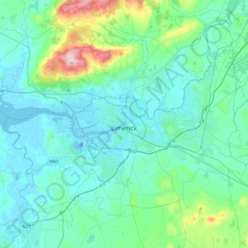
Naam: Topografische kaart Limerick, hoogte, reliëf.
Locatie: Limerick, County Limerick, Munster, Irland (52.57210 -8.80708 52.75738 -8.44254)
Gemiddelde hoogte: 45 m
Minimale hoogte: -26 m
Maximale hoogte: 303 m
Neben Dublin und Cork ist Limerick eines der wichtigsten Zentren für höhere Bildung in Irland. Es beherbergt die University of Limerick mit etwa 11.000 Studenten. sowie das Limerick Institute of Technology mit etwa 3900 Studenten.
Andere topografische kaarten
Klik op een kaart om zijn topografie, zijn hoogte en zijn reliëf te bekijken.
Abbeyfeale
Irland > County Limerick > The Municipal District of Newcastle West
Abbeyfeale, The Municipal District of Newcastle West, County Limerick, Munster, Irland
Gemiddelde hoogte: 150 m
Abbeyfeale
Irland > County Limerick > The Municipal District of Newcastle West > Abbeyfeale
Abbeyfeale, The Municipal District of Newcastle West, County Limerick, Munster, Irland
Gemiddelde hoogte: 122 m