
Topografische kaart Negros Oriental
Interactieve kaart
Klik op de kaart om de hoogte weer te geven.
Over deze kaart
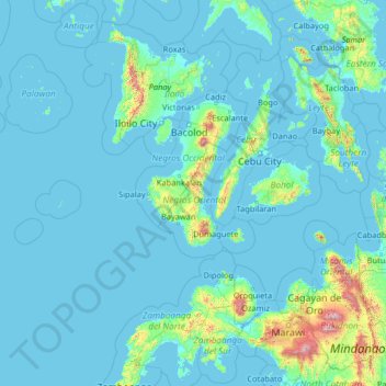
Naam: Topografische kaart Negros Oriental, hoogte, reliëf.
Locatie: Negros Oriental, Central Visayas, Philippines (7.19000 120.44000 12.31000 125.56000)
Gemiddelde hoogte: 101 m
Minimale hoogte: -2 m
Maximale hoogte: 2.797 m
The province's topography is characterized by low, grooved mountain ranges of which some lie close to the shoreline. At the southern end of the province is Mount Talinis, also known as Cuernos de Negros ("Horns of Negros"), which is a dormant complex volcano which rises to a height of 2,000 metres (6,600 ft). At the northern end of the province is the active Kanlaon Volcano, the highest peak of the island region with a height of 2,465 metres (8,087 ft). There are a few flatlands and plateaus in the interior to the southwest of the province, which includes the Tablas Plateau.
Andere topografische kaarten
Klik op een kaart om zijn topografie, zijn hoogte en zijn reliëf te bekijken.
Lake Danao
Philippines > Negros Oriental > Sibulan
Lake Danao, Sibulan, Negros Oriental, Central Visayas, Philippines
Gemiddelde hoogte: 956 m
Dumaguete
Dumaguete, Negros Oriental, Central Visayas, 6200, Philippines
Gemiddelde hoogte: 55 m
Bacong
Bacong, Negros Oriental, Central Visayas, 6216, Philippines
Gemiddelde hoogte: 36 m
Manjuyod
Philippines > Negros Oriental > Manjuyod
Manjuyod, Negros Oriental, Central Visayas, Philippines
Gemiddelde hoogte: 72 m
Canlaon
Philippines > Negros Oriental > Canlaon
Canlaon, Negros Oriental, Central Visayas, 6223, Philippines
Gemiddelde hoogte: 428 m