
Topografische kaart Dumaguete
Interactieve kaart
Klik op de kaart om de hoogte weer te geven.
Over deze kaart
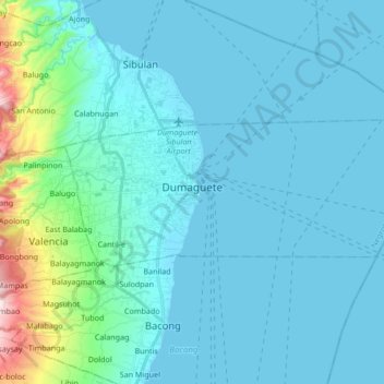
Naam: Topografische kaart Dumaguete, hoogte, reliëf.
Locatie: Dumaguete, Negros Oriental, Central Visayas, 6200, Philippines (9.27093 123.25178 9.33511 123.42084)
Gemiddelde hoogte: 55 m
Minimale hoogte: 0 m
Maximale hoogte: 500 m
As a coastal city, it is bounded on the east by the Bohol Sea and the Tañon Strait, serving as a natural border of southeastern Negros Island Region to the neighboring Central Visayas. The city's topography is generally flat from two to six kilometers from the shoreline. It slopes gently upwards to the adjoining municipality of Valencia. The highest ground elevation is located at the boundary of the municipality of Valencia, about one hundred meters above mean sea level. About 93% of the land have slopes of less than 3%. The remaining areas have 3% to 5% slope.
Andere topografische kaarten
Klik op een kaart om zijn topografie, zijn hoogte en zijn reliëf te bekijken.
Lake Danao
Philippines > Negros Oriental > Sibulan
Lake Danao, Sibulan, Negros Oriental, Central Visayas, Philippines
Gemiddelde hoogte: 956 m
Bacong
Bacong, Negros Oriental, Central Visayas, 6216, Philippines
Gemiddelde hoogte: 36 m
Manjuyod
Philippines > Negros Oriental > Manjuyod
Manjuyod, Negros Oriental, Central Visayas, Philippines
Gemiddelde hoogte: 72 m
Negros Oriental
Negros Oriental, Central Visayas, Philippines
Gemiddelde hoogte: 101 m
Canlaon
Philippines > Negros Oriental > Canlaon
Canlaon, Negros Oriental, Central Visayas, 6223, Philippines
Gemiddelde hoogte: 428 m