
Topografische kaart Racovița
Interactieve kaart
Klik op de kaart om de hoogte weer te geven.
Over deze kaart
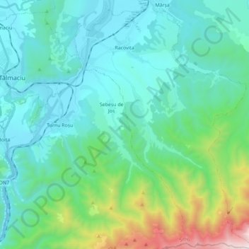
Naam: Topografische kaart Racovița, hoogte, reliëf.
Locatie: Racovița, Sibiu, Romania (45.58117 24.30931 45.70228 24.43388)
Gemiddelde hoogte: 674 m
Minimale hoogte: 350 m
Maximale hoogte: 2.119 m
Racovița Commune is situated at the base of Suru Peak (2,281 m or 7,484 ft) on the contact between the foothills of the Făgăraș Mountains and the low terrace of the floodplain, on the left bank of the river Olt, at an altitude of 385 meters. The commune borders to the north and northeast with the town Avrig; the border, which extends from the confluence of the small river Mârșa with the Olt to the Sorliței Peak, was established after the year 1200 and is marked with border signs called 'morminți'.
Andere topografische kaarten
Klik op een kaart om zijn topografie, zijn hoogte en zijn reliëf te bekijken.
Bâlea Lake
Romania > Sibiu > Cârțișoara
Bâlea Lake, Cârțișoara, Sibiu, Romania
Gemiddelde hoogte: 2.080 m
Lacul fără fund
Romania > Sibiu > Ocna Sibiului > Ocna Sibiului
Lacul fără fund, Ocna Sibiului, Sibiu, Romania
Gemiddelde hoogte: 414 m
Miercurea Sibiului
Romania > Sibiu > Miercurea Sibiului
Miercurea Sibiului, Sibiu, Romania
Gemiddelde hoogte: 432 m
Porumbacu
Romania > Sibiu > Porumbacu de Jos
Porumbacu, Porumbacu de Jos, Sibiu, 557192, Romania
Gemiddelde hoogte: 466 m