
Doe een donatie
Rust jezelf uit voor je volgende avontuur:
Als Amazon-partner verdient deze site een commissie op in aanmerking komende aankopen, zonder extra kosten voor jou.
Topografische kaart Bâlea Lake
Klik op de kaart om de hoogte weer te geven.
Doe een donatie
Rust jezelf uit voor je volgende avontuur:
Als Amazon-partner verdient deze site een commissie op in aanmerking komende aankopen, zonder extra kosten voor jou.
Bâlea Lake
Bâlea Lake (Romanian: Lacul Bâlea or Bâlea Lac, pronounced [ˈbɨle̯a]; Hungarian: Bilea-tó) is a glacier lake situated at 2,034 m of altitude in the Făgăraș Mountains, in central Romania, in Cârțișoara, Sibiu County. There are two chalets opened all the year round, a meteorological station and a mountain rescue (Salvamont) station. It is accessible by car on the Transfăgărășan road during the summer, and the rest of the year by a cable car from the "Bâlea Cascadă" chalet.
Doe een donatie
Rust jezelf uit voor je volgende avontuur:
Als Amazon-partner verdient deze site een commissie op in aanmerking komende aankopen, zonder extra kosten voor jou.
Over deze kaart
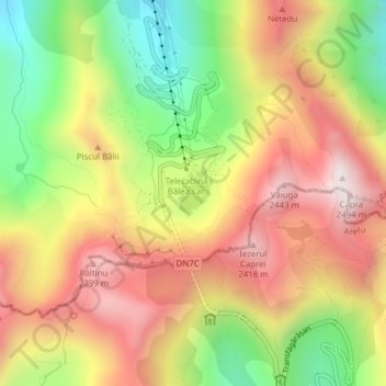
Naam: Topografische kaart Bâlea Lake, hoogte, reliëf.
Locatie: Bâlea Lake, Cârțișoara, Sibiu, Romania (45.60176 24.61549 45.60483 24.61897)
Gemiddelde hoogte: 2.080 m
Minimale hoogte: 1.662 m
Maximale hoogte: 2.457 m
Doe een donatie
Rust jezelf uit voor je volgende avontuur:
Als Amazon-partner verdient deze site een commissie op in aanmerking komende aankopen, zonder extra kosten voor jou.