
Topografische kaart Častá
Interactieve kaart
Klik op de kaart om de hoogte weer te geven.
Over deze kaart
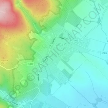
Naam: Topografische kaart Častá, hoogte, reliëf.
Gemiddelde hoogte: 262 m
Minimale hoogte: 193 m
Maximale hoogte: 445 m
The village lies at an altitude of 245 meters and covers an area of 35.24 km². It has population of 2,078 people.
Andere topografische kaarten
Klik op een kaart om zijn topografie, zijn hoogte en zijn reliëf te bekijken.
Vištuk
Slovakia > Region of Bratislava > District of Pezinok
Vištuk, District of Pezinok, Region of Bratislava, 900 85, Slovakia
Gemiddelde hoogte: 185 m
Pezinok
Slovakia > Region of Bratislava > District of Pezinok
Pezinok, District of Pezinok, Region of Bratislava, Slovakia
Gemiddelde hoogte: 300 m
Štefanová
Slovakia > Region of Bratislava > District of Pezinok
Štefanová, District of Pezinok, Region of Bratislava, Slovakia
Gemiddelde hoogte: 210 m