
Topografische kaart Vištuk
Interactieve kaart
Klik op de kaart om de hoogte weer te geven.
Over deze kaart
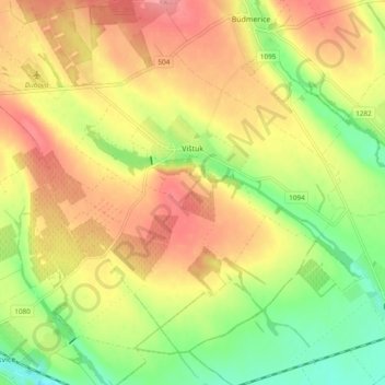
Naam: Topografische kaart Vištuk, hoogte, reliëf.
Gemiddelde hoogte: 185 m
Minimale hoogte: 142 m
Maximale hoogte: 220 m
Andere topografische kaarten
Klik op een kaart om zijn topografie, zijn hoogte en zijn reliëf te bekijken.
Častá
Slovakia > Region of Bratislava > District of Pezinok
Častá, District of Pezinok, Region of Bratislava, 900 89, Slovakia
Gemiddelde hoogte: 262 m
Pezinok
Slovakia > Region of Bratislava > District of Pezinok
Pezinok, District of Pezinok, Region of Bratislava, Slovakia
Gemiddelde hoogte: 300 m
Štefanová
Slovakia > Region of Bratislava > District of Pezinok
Štefanová, District of Pezinok, Region of Bratislava, Slovakia
Gemiddelde hoogte: 210 m