
Topografische kaart Badwater Basin
Interactieve kaart
Klik op de kaart om de hoogte weer te geven.
Over deze kaart
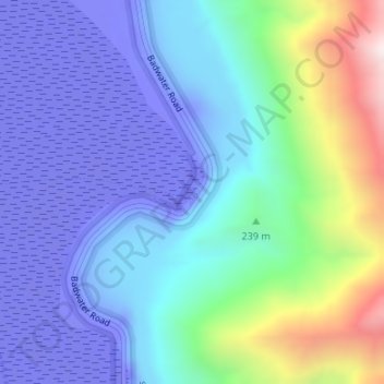
Naam: Topografische kaart Badwater Basin, hoogte, reliëf.
Locatie: Badwater Basin, Inyo County, California, United States (36.22999 -116.76767 36.23055 -116.76716)
Gemiddelde hoogte: 152 m
Minimale hoogte: -84 m
Maximale hoogte: 914 m
The pool is not the lowest point of the basin: the lowest point (which is only slightly lower) is several miles to the west and varies in position, depending on rainfall and evaporation patterns. The salt flats are hazardous to traverse (in many cases being only a thin white crust over mud), and so the sign marking the low point is at the pool instead. The basin was considered the lowest elevation in the Western Hemisphere until the discovery of Laguna del Carbón in Argentina at −344 ft (−105 m).
Andere topografische kaarten
Klik op een kaart om zijn topografie, zijn hoogte en zijn reliëf te bekijken.
Mount Starr
United States > California > Inyo County
Mount Starr, Inyo County, California, United States
Gemiddelde hoogte: 3.509 m
Kearsarge Peak
United States > California > Inyo County
Kearsarge Peak, Inyo County, California, United States
Gemiddelde hoogte: 3.394 m
Mount LeConte
United States > California > Inyo County
Mount LeConte, Inyo County, California, United States
Gemiddelde hoogte: 3.789 m
Kearsarge
United States > California > Inyo County
Kearsarge, Inyo County, California, United States
Gemiddelde hoogte: 1.159 m
Independence
United States > California > Inyo County
Independence, Inyo County, CAL Fire Southern Region, California, 93526, United States
Gemiddelde hoogte: 1.210 m
Death Valley Junction
United States > California > Inyo County
Death Valley Junction, Inyo County, California, United States
Gemiddelde hoogte: 627 m
Dante's View
United States > California > Inyo County
Dante's View, Inyo County, California, United States
Gemiddelde hoogte: 1.403 m
Lake Sabrina
United States > California > Inyo County
Lake Sabrina, Inyo County, California, United States
Gemiddelde hoogte: 3.033 m
Tecopa
United States > California > Inyo County > Tecopa
Tecopa, Inyo County, California, United States
Gemiddelde hoogte: 508 m
Mount Whitney
United States > California > Inyo County
Mount Whitney, Inyo County, California, United States
Gemiddelde hoogte: 3.903 m
Bishop
United States > California > Inyo County
Bishop, Inyo County, California, United States
Gemiddelde hoogte: 1.265 m
Owens River
United States > California > Inyo County
Owens River, Inyo County, California, United States
Gemiddelde hoogte: 1.183 m
Lone Pine
United States > California > Inyo County
Lone Pine, Inyo County, CAL Fire Southern Region, California, 93545, United States
Gemiddelde hoogte: 1.298 m
Furnace Creek
United States > California > Inyo County
Furnace Creek, Inyo County, California, 92328, United States
Gemiddelde hoogte: -27 m
Crater
United States > California > Inyo County
Crater, Inyo County, California, United States
Gemiddelde hoogte: 1.657 m