
Topografische kaart Oyón/Oion
Interactieve kaart
Klik op de kaart om de hoogte weer te geven.
Over deze kaart
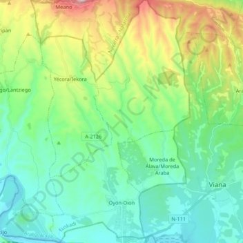
Naam: Topografische kaart Oyón/Oion, hoogte, reliëf.
Gemiddelde hoogte: 572 m
Minimale hoogte: 369 m
Maximale hoogte: 1.146 m
Andere topografische kaarten
Klik op een kaart om zijn topografie, zijn hoogte en zijn reliëf te bekijken.
Labastida/Bastida
Spain > Autonomous Community of the Basque Country > Arabako Errioxa/Rioja Alavesa
Labastida/Bastida, Arabako Errioxa/Rioja Alavesa, Álava, Autonomous Community of the Basque Country, 01330, Spain
Gemiddelde hoogte: 611 m
Salinillas de Buradón/Gatzaga Buradon
Spain > Autonomous Community of the Basque Country > Arabako Errioxa/Rioja Alavesa > Labastida/Bastida
Salinillas de Buradón/Gatzaga Buradon, Labastida/Bastida, Arabako Errioxa/Rioja Alavesa, Álava, Autonomous Community of the Basque Country, Spain
Gemiddelde hoogte: 599 m
Laguardia
Spain > Autonomous Community of the Basque Country > Arabako Errioxa/Rioja Alavesa
Laguardia, Arabako Errioxa/Rioja Alavesa, Álava, Autonomous Community of the Basque Country, Spain
Gemiddelde hoogte: 592 m