
Topografische kaart Labastida/Bastida
Interactieve kaart
Klik op de kaart om de hoogte weer te geven.
Over deze kaart
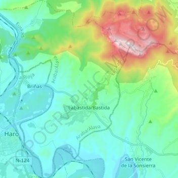
Naam: Topografische kaart Labastida/Bastida, hoogte, reliëf.
Gemiddelde hoogte: 611 m
Minimale hoogte: 423 m
Maximale hoogte: 1.252 m
The town is at 529m altitude, and is positioned between the River Ebro and the Sierra de Toloño mountain range.
Andere topografische kaarten
Klik op een kaart om zijn topografie, zijn hoogte en zijn reliëf te bekijken.
Salinillas de Buradón/Gatzaga Buradon
Spain > Autonomous Community of the Basque Country > Arabako Errioxa/Rioja Alavesa > Labastida/Bastida
Salinillas de Buradón/Gatzaga Buradon, Labastida/Bastida, Arabako Errioxa/Rioja Alavesa, Álava, Autonomous Community of the Basque Country, Spain
Gemiddelde hoogte: 599 m
Laguardia
Spain > Autonomous Community of the Basque Country > Arabako Errioxa/Rioja Alavesa
Laguardia, Arabako Errioxa/Rioja Alavesa, Álava, Autonomous Community of the Basque Country, Spain
Gemiddelde hoogte: 592 m
Oyón/Oion
Spain > Autonomous Community of the Basque Country > Arabako Errioxa/Rioja Alavesa
Oyón/Oion, Arabako Errioxa/Rioja Alavesa, Álava, Autonomous Community of the Basque Country, 01320, Spain
Gemiddelde hoogte: 572 m