
Topografische kaart Thousand Oaks
Interactieve kaart
Klik op de kaart om de hoogte weer te geven.
Over deze kaart
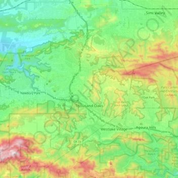
Naam: Topografische kaart Thousand Oaks, hoogte, reliëf.
Gemiddelde hoogte: 333 m
Minimale hoogte: 62 m
Maximale hoogte: 918 m
The northern parts consist of mountainous terrain in the Simi Hills, Conejo Mountains and Mount Clef Ridge. Narrow canyons such as Hill Canyon cut through the steeper mountainous areas. Conejo Mountain and Conejo Grade are found in westernmost Newbury Park, while the southernmost parts of Thousand Oaks are made up of Russell Valley, Hidden Valley and the steep rugged slopes of the Santa Monica Mountains. The elevation ranges from 500 feet in the northwest to the 2,403 feet Simi Peak. The major drainage is Conejo Creek (Arroyo Conejo).
Andere topografische kaarten
Klik op een kaart om zijn topografie, zijn hoogte en zijn reliëf te bekijken.
Simi Valley
United States > California > Ventura County
Simi Valley, Ventura County, CAL Fire Contract Counties, California, United States
Gemiddelde hoogte: 405 m
Santa Susana
United States > California > Ventura County > Simi Valley
Santa Susana, Simi Valley, Ventura County, California, 93064, United States
Gemiddelde hoogte: 324 m
Ventura
United States > California > Ventura County
Ventura, Ventura County, CAL Fire Contract Counties, California, United States
Gemiddelde hoogte: 134 m
Oak Park
United States > California > Ventura County
Oak Park, Ventura County, CAL Fire Southern Region, California, 91377, United States
Gemiddelde hoogte: 378 m
Camarillo
United States > California > Ventura County
Camarillo, Ventura County, California, United States
Gemiddelde hoogte: 90 m
Channel Islands National Park
United States > California > Ventura County
Channel Islands National Park, Ventura County, California, United States
Gemiddelde hoogte: 6 m