
Topografische kaart Oak Park
Interactieve kaart
Klik op de kaart om de hoogte weer te geven.
Over deze kaart
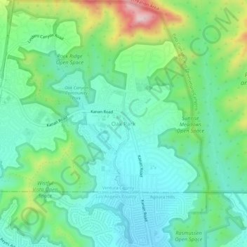
Naam: Topografische kaart Oak Park, hoogte, reliëf.
Gemiddelde hoogte: 378 m
Minimale hoogte: 281 m
Maximale hoogte: 638 m
Andere topografische kaarten
Klik op een kaart om zijn topografie, zijn hoogte en zijn reliëf te bekijken.
Simi Valley
United States > California > Ventura County
Simi Valley, Ventura County, CAL Fire Contract Counties, California, United States
Gemiddelde hoogte: 405 m
Santa Susana
United States > California > Ventura County > Simi Valley
Santa Susana, Simi Valley, Ventura County, California, 93064, United States
Gemiddelde hoogte: 324 m
Ventura
United States > California > Ventura County
Ventura, Ventura County, CAL Fire Contract Counties, California, United States
Gemiddelde hoogte: 134 m
Thousand Oaks
United States > California > Ventura County
Thousand Oaks, Ventura County, CAL Fire Southern Region, California, United States
Gemiddelde hoogte: 333 m
Camarillo
United States > California > Ventura County
Camarillo, Ventura County, California, United States
Gemiddelde hoogte: 90 m
Channel Islands National Park
United States > California > Ventura County
Channel Islands National Park, Ventura County, California, United States
Gemiddelde hoogte: 6 m