
Topografische kaart Luvuvhu
Interactieve kaart
Klik op de kaart om de hoogte weer te geven.
Over deze kaart
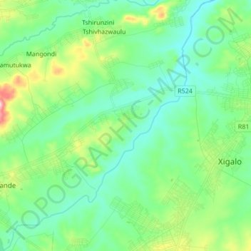
Naam: Topografische kaart Luvuvhu, hoogte, reliëf.
Locatie: Luvuvhu, Thulamela Local Municipality, Limpopo, RSA (-22.98179 30.59692 -22.85654 30.71082)
Gemiddelde hoogte: 511 m
Minimale hoogte: 452 m
Maximale hoogte: 694 m
Andere topografische kaarten
Klik op een kaart om zijn topografie, zijn hoogte en zijn reliëf te bekijken.
Mutshindudi
RSA > Limpopo > Thulamela Local Municipality
Mutshindudi, Thulamela Local Municipality, Limpopo, RSA
Gemiddelde hoogte: 495 m
Vondo Dam
RSA > Limpopo > Thulamela Local Municipality
Vondo Dam, Thulamela Local Municipality, Limpopo, RSA
Gemiddelde hoogte: 908 m
Makuleke
RSA > Limpopo > Thulamela Local Municipality
Makuleke, D3639, Thulamela Ward 7, Thulamela Local Municipality, Limpopo, RSA
Gemiddelde hoogte: 417 m