
Topografische kaart Irish Lake
Interactieve kaart
Klik op de kaart om de hoogte weer te geven.
Over deze kaart
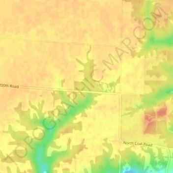
Naam: Topografische kaart Irish Lake, hoogte, reliëf.
Gemiddelde hoogte: 214 m
Minimale hoogte: 181 m
Maximale hoogte: 225 m
Andere topografische kaarten
Klik op een kaart om zijn topografie, zijn hoogte en zijn reliëf te bekijken.
Charleston Lake
USA > Illinois > Charleston
Charleston Lake, Charleston, Coles County, Illinois, USA
Gemiddelde hoogte: 193 m
Garfield Ridge
Garfield Ridge, Chicago, Cook County, Illinois, USA
Gemiddelde hoogte: 184 m
Baldwin Heights
USA > Illinois > Baldwin Heights
Baldwin Heights, Jefferson County, Illinois, 62848, USA
Gemiddelde hoogte: 165 m
Hainesville
USA > Illinois > Hainesville
Hainesville, Lake County, Illinois, USA
Gemiddelde hoogte: 242 m
Montague Island
Montague Island, Rockford, Winnebago County, Illinois, 61104, USA
Gemiddelde hoogte: 254 m
Arrowsmith
USA > Illinois > Arrowsmith
Arrowsmith, McLean County, Illinois, USA
Gemiddelde hoogte: 266 m
Illinois Medical District
USA > Illinois > Illinois Medical District
Illinois Medical District, Cook County, Illinois, USA
Gemiddelde hoogte: 182 m
Cooksville
USA > Illinois > Cooksville
Cooksville, McLean County, Illinois, USA
Gemiddelde hoogte: 235 m
Mount Carmel
USA > Illinois > Mount Carmel
Mount Carmel, Wabash County, Illinois, USA
Gemiddelde hoogte: 128 m
Heidecke Lake
USA > Illinois > Harrisonville
Heidecke Lake, North Jugtown Road, Harrisonville, Grundy County, Illinois, 60450, USA
Gemiddelde hoogte: 156 m