
Topografische kaart Smyth County
Interactieve kaart
Klik op de kaart om de hoogte weer te geven.
Over deze kaart
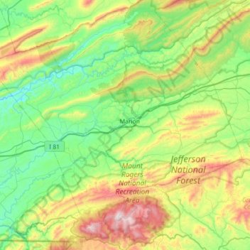
Naam: Topografische kaart Smyth County, hoogte, reliëf.
Locatie: Smyth County, Virginia, United States of America (36.63508 -81.83382 37.01715 -81.26219)
Gemiddelde hoogte: 852 m
Minimale hoogte: 511 m
Maximale hoogte: 1.730 m
Andere topografische kaarten
Klik op een kaart om zijn topografie, zijn hoogte en zijn reliëf te bekijken.
Saltville
United States of America > Virginia > Saltville
Saltville, Smyth County, Virginia, 24370, United States of America
Gemiddelde hoogte: 617 m
Arlington County
United States of America > Virginia
Arlington County, Virginia, United States of America
Gemiddelde hoogte: 54 m
Augusta County
United States of America > Virginia
Augusta County, Virginia, United States of America
Gemiddelde hoogte: 570 m