
Topografische kaart Augusta County
Interactieve kaart
Klik op de kaart om de hoogte weer te geven.
Over deze kaart
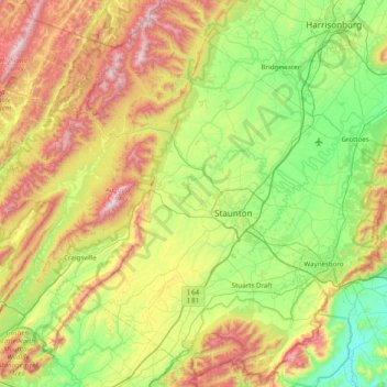
Naam: Topografische kaart Augusta County, hoogte, reliëf.
Locatie: Augusta County, Virginia, United States of America (37.88586 -79.53328 38.48059 -78.75125)
Gemiddelde hoogte: 570 m
Minimale hoogte: 170 m
Maximale hoogte: 1.342 m
Andere topografische kaarten
Klik op een kaart om zijn topografie, zijn hoogte en zijn reliëf te bekijken.
Saltville
United States of America > Virginia > Saltville
Saltville, Smyth County, Virginia, 24370, United States of America
Gemiddelde hoogte: 617 m
Arlington County
United States of America > Virginia
Arlington County, Virginia, United States of America
Gemiddelde hoogte: 54 m
Smyth County
United States of America > Virginia
Smyth County, Virginia, United States of America
Gemiddelde hoogte: 852 m