
Topografische kaart Panzhihua City
Interactieve kaart
Klik op de kaart om de hoogte weer te geven.
Over deze kaart
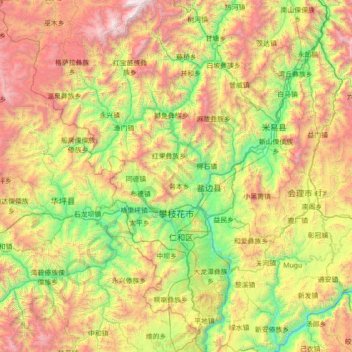
Naam: Topografische kaart Panzhihua City, hoogte, reliëf.
Locatie: Panzhihua City, Sichuan, 617000, PRC (26.08637 101.13520 27.34647 102.24567)
Gemiddelde hoogte: 1.994 m
Minimale hoogte: 873 m
Maximale hoogte: 4.212 m
Andere topografische kaarten
Klik op een kaart om zijn topografie, zijn hoogte en zijn reliëf te bekijken.
Wenchuan County
Wenchuan County, Ngawa Tibetan and Qiang Autonomous Prefecture, Sichuan, PRC
Gemiddelde hoogte: 2.775 m
Yanbian County
PRC > Sichuan > Panzhihua City
Yanbian County, Panzhihua City, Sichuan, PRC
Gemiddelde hoogte: 1.974 m
Jiuzhai Valley National Park
Jiuzhai Valley National Park, 日则沟, Zechawa, Jiuzhaigou County, Ngawa Tibetan and Qiang Autonomous Prefecture, Sichuan, PRC
Gemiddelde hoogte: 3.421 m
Jialing River
Jialing River, Gaoping District, Nanchong City, Sichuan, 400000, PRC
Gemiddelde hoogte: 516 m
Hanshui River
Hanshui River, Dachuan District, Dazhou City, Sichuan, PRC
Gemiddelde hoogte: 423 m
Yalong River
Yalong River, Litang County, Garzê Tibetan Autonomous Prefecture, Sichuan, 615613, PRC
Gemiddelde hoogte: 3.378 m