
Topografische kaart Pujiang County
Interactieve kaart
Klik op de kaart om de hoogte weer te geven.
Over deze kaart
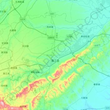
Naam: Topografische kaart Pujiang County, hoogte, reliëf.
Locatie: Pujiang County, Chengdu City, Sichuan, PRC (30.09415 103.30558 30.33803 103.67111)
Gemiddelde hoogte: 584 m
Minimale hoogte: 438 m
Maximale hoogte: 1.106 m
Andere topografische kaarten
Klik op een kaart om zijn topografie, zijn hoogte en zijn reliëf te bekijken.
Wenchuan County
Wenchuan County, Ngawa Tibetan and Qiang Autonomous Prefecture, Sichuan, PRC
Gemiddelde hoogte: 2.775 m
Yanbian County
PRC > Sichuan > Panzhihua City
Yanbian County, Panzhihua City, Sichuan, PRC
Gemiddelde hoogte: 1.974 m
Jiuzhai Valley National Park
Jiuzhai Valley National Park, 日则沟, Zechawa, Jiuzhaigou County, Ngawa Tibetan and Qiang Autonomous Prefecture, Sichuan, PRC
Gemiddelde hoogte: 3.421 m