
Topografische kaart Troistorrents
Interactieve kaart
Klik op de kaart om de hoogte weer te geven.
Over deze kaart
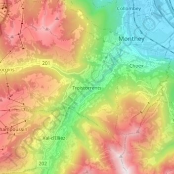
Naam: Topografische kaart Troistorrents, hoogte, reliëf.
Locatie: Troistorrents, Monthey, Wallis, Switzerland (46.19876 6.82059 46.25929 6.94397)
Gemiddelde hoogte: 1.231 m
Minimale hoogte: 389 m
Maximale hoogte: 2.281 m
Andere topografische kaarten
Klik op een kaart om zijn topografie, zijn hoogte en zijn reliëf te bekijken.
Val-d'Illiez
Switzerland > Wallis > Monthey
Val-d'Illiez, Monthey, Wallis, 1873, Switzerland
Gemiddelde hoogte: 1.672 m
Lac de Taney
Switzerland > Wallis > Monthey > Vouvry > Taney
Lac de Taney, Taney, Vouvry, Monthey, Wallis, 1896, Switzerland
Gemiddelde hoogte: 1.430 m
Champéry
Switzerland > Wallis > Monthey
Champéry, Monthey, Wallis, 1874, Switzerland
Gemiddelde hoogte: 1.883 m
Saint-Gingolph
Switzerland > Wallis > Monthey > Saint-Gingolph
Saint-Gingolph, Monthey, Wallis, 1898, Switzerland
Gemiddelde hoogte: 1.104 m