
Topografische kaart Monthey
Interactieve kaart
Klik op de kaart om de hoogte weer te geven.
Over deze kaart
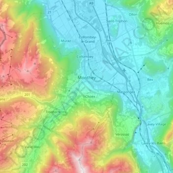
Naam: Topografische kaart Monthey, hoogte, reliëf.
Locatie: Monthey, Wallis, Switzerland (46.19285 6.80332 46.30000 6.97922)
Gemiddelde hoogte: 933 m
Minimale hoogte: 374 m
Maximale hoogte: 2.271 m
Andere topografische kaarten
Klik op een kaart om zijn topografie, zijn hoogte en zijn reliëf te bekijken.
Val-d'Illiez
Switzerland > Wallis > Monthey
Val-d'Illiez, Monthey, Wallis, 1873, Switzerland
Gemiddelde hoogte: 1.672 m
Lac de Taney
Switzerland > Wallis > Monthey > Vouvry > Taney
Lac de Taney, Taney, Vouvry, Monthey, Wallis, 1896, Switzerland
Gemiddelde hoogte: 1.430 m
Troistorrents
Switzerland > Wallis > Monthey
Troistorrents, Monthey, Wallis, Switzerland
Gemiddelde hoogte: 1.231 m
Champéry
Switzerland > Wallis > Monthey
Champéry, Monthey, Wallis, 1874, Switzerland
Gemiddelde hoogte: 1.883 m
Saint-Gingolph
Switzerland > Wallis > Monthey > Saint-Gingolph
Saint-Gingolph, Monthey, Wallis, 1898, Switzerland
Gemiddelde hoogte: 1.104 m