
Topografische kaart Kootenay National Park
Interactieve kaart
Klik op de kaart om de hoogte weer te geven.
Over deze kaart
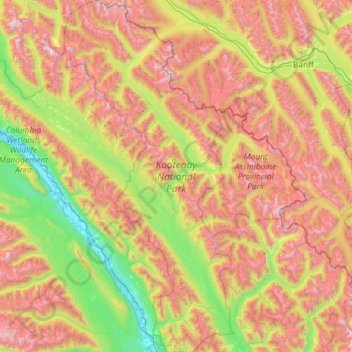
Naam: Topografische kaart Kootenay National Park, hoogte, reliëf.
Gemiddelde hoogte: 1.832 m
Minimale hoogte: 786 m
Maximale hoogte: 3.410 m
L'altitude varie de 918 m à 3 424 m au sommet de la Deltaform Mountain. Le parc s'étend sur 1 406 km2.
Andere topografische kaarten
Klik op een kaart om zijn topografie, zijn hoogte en zijn reliëf te bekijken.
Radium Hot Springs
Canada > Colombie-Britannique > Regional District of East Kootenay
Radium Hot Springs, Regional District of East Kootenay, Colombie-Britannique, V0A 1M0, Canada
Gemiddelde hoogte: 913 m
Elkford
Canada > Colombie-Britannique > Regional District of East Kootenay
Elkford, Regional District of East Kootenay, Colombie-Britannique, Canada
Gemiddelde hoogte: 1.895 m
Fernie
Canada > Colombie-Britannique > Regional District of East Kootenay > Fernie
Fernie, Regional District of East Kootenay, Colombie-Britannique, V0B 1M0, Canada
Gemiddelde hoogte: 1.551 m
Shuswap
Canada > Colombie-Britannique > Regional District of East Kootenay > Area F (Columbia Lake/Windermere Lake) > Shuswap
Shuswap, Area F (Columbia Lake/Windermere Lake), Regional District of East Kootenay, Colombie-Britannique, V0A 1K3, Canada
Gemiddelde hoogte: 926 m