
Topografische kaart Elkford
Interactieve kaart
Klik op de kaart om de hoogte weer te geven.
Over deze kaart
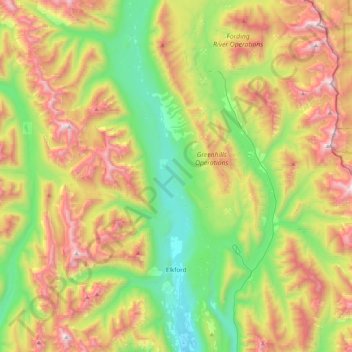
Naam: Topografische kaart Elkford, hoogte, reliëf.
Gemiddelde hoogte: 1.895 m
Minimale hoogte: 1.228 m
Maximale hoogte: 2.905 m
Elkford est connu comme la communauté la plus haute en altitude.
Andere topografische kaarten
Klik op een kaart om zijn topografie, zijn hoogte en zijn reliëf te bekijken.
Kootenay National Park
Canada > Colombie-Britannique > Regional District of East Kootenay
Kootenay National Park, Regional District of East Kootenay, Colombie-Britannique, Canada
Gemiddelde hoogte: 1.832 m
Radium Hot Springs
Canada > Colombie-Britannique > Regional District of East Kootenay
Radium Hot Springs, Regional District of East Kootenay, Colombie-Britannique, V0A 1M0, Canada
Gemiddelde hoogte: 913 m
Fernie
Canada > Colombie-Britannique > Regional District of East Kootenay > Fernie
Fernie, Regional District of East Kootenay, Colombie-Britannique, V0B 1M0, Canada
Gemiddelde hoogte: 1.551 m
Shuswap
Canada > Colombie-Britannique > Regional District of East Kootenay > Area F (Columbia Lake/Windermere Lake) > Shuswap
Shuswap, Area F (Columbia Lake/Windermere Lake), Regional District of East Kootenay, Colombie-Britannique, V0A 1K3, Canada
Gemiddelde hoogte: 926 m