
Topografische kaart Kremmling
Interactieve kaart
Klik op de kaart om de hoogte weer te geven.
Over deze kaart
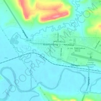
Naam: Topografische kaart Kremmling, hoogte, reliëf.
Locatie: Kremmling, Grand County, Colorado, 80459, United States (40.04836 -106.40161 40.06475 -106.35584)
Gemiddelde hoogte: 2.251 m
Minimale hoogte: 2.231 m
Maximale hoogte: 2.338 m
Andere topografische kaarten
Klik op een kaart om zijn topografie, zijn hoogte en zijn reliëf te bekijken.
Grand Lake
United States > Colorado > Grand County
Grand Lake, Grand County, Colorado, United States
Gemiddelde hoogte: 2.630 m
Morse Mountain
United States > Colorado > Grand County
Morse Mountain, Grand County, Colorado, United States
Gemiddelde hoogte: 2.924 m
Fraser
United States > Colorado > Grand County
Fraser, Grand County, Colorado, 80442, United States
Gemiddelde hoogte: 2.696 m
Winter Park
United States > Colorado > Grand County
Winter Park, Grand County, Colorado, United States
Gemiddelde hoogte: 3.068 m
Lake Granby
United States > Colorado > Grand County
Lake Granby, Grand County, Colorado, United States
Gemiddelde hoogte: 2.608 m
Granby
United States > Colorado > Grand County
Granby, Grand County, Colorado, United States
Gemiddelde hoogte: 2.555 m
Rabbit Ears Pass
United States > Colorado > Grand County
Rabbit Ears Pass, Grand County, Colorado, United States
Gemiddelde hoogte: 2.852 m
Bottle Peak
United States > Colorado > Grand County
Bottle Peak, Grand County, Colorado, United States
Gemiddelde hoogte: 3.283 m
Elk Mountain
United States > Colorado > Grand County
Elk Mountain, Grand County, Colorado, United States
Gemiddelde hoogte: 3.218 m
Tabernash
United States > Colorado > Grand County
Tabernash, Grand County, Colorado, 80478, United States
Gemiddelde hoogte: 2.592 m
Mount Flora
United States > Colorado > Grand County
Mount Flora, Grand County, Colorado, United States
Gemiddelde hoogte: 3.728 m
Indian Peaks Wilderness
United States > Colorado > Grand County
Indian Peaks Wilderness, Grand County, Colorado, United States
Gemiddelde hoogte: 3.080 m