
Topografische kaart Indian Peaks Wilderness
Interactieve kaart
Klik op de kaart om de hoogte weer te geven.
Over deze kaart
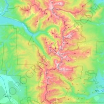
Naam: Topografische kaart Indian Peaks Wilderness, hoogte, reliëf.
Gemiddelde hoogte: 3.080 m
Minimale hoogte: 2.492 m
Maximale hoogte: 4.096 m
The area encompasses a stretch of the Front Range. It includes 7 peaks over 13,000 feet (4,000 m) in elevation. The highest point is North Arapaho Peak at 13,502 feet (4,115 m). The peaks are all within 100 feet (30 m) of elevation of each other. A portion of the area, encompassing the headwaters of North Boulder Creek, is closed to the public as it is the City of Boulder watershed.
Andere topografische kaarten
Klik op een kaart om zijn topografie, zijn hoogte en zijn reliëf te bekijken.
Grand Lake
United States > Colorado > Grand County
Grand Lake, Grand County, Colorado, United States
Gemiddelde hoogte: 2.630 m
Morse Mountain
United States > Colorado > Grand County
Morse Mountain, Grand County, Colorado, United States
Gemiddelde hoogte: 2.924 m
Fraser
United States > Colorado > Grand County
Fraser, Grand County, Colorado, 80442, United States
Gemiddelde hoogte: 2.696 m
Winter Park
United States > Colorado > Grand County
Winter Park, Grand County, Colorado, United States
Gemiddelde hoogte: 3.068 m
Lake Granby
United States > Colorado > Grand County
Lake Granby, Grand County, Colorado, United States
Gemiddelde hoogte: 2.608 m
Granby
United States > Colorado > Grand County
Granby, Grand County, Colorado, United States
Gemiddelde hoogte: 2.555 m
Rabbit Ears Pass
United States > Colorado > Grand County
Rabbit Ears Pass, Grand County, Colorado, United States
Gemiddelde hoogte: 2.852 m
Bottle Peak
United States > Colorado > Grand County
Bottle Peak, Grand County, Colorado, United States
Gemiddelde hoogte: 3.283 m
Elk Mountain
United States > Colorado > Grand County
Elk Mountain, Grand County, Colorado, United States
Gemiddelde hoogte: 3.218 m
Tabernash
United States > Colorado > Grand County
Tabernash, Grand County, Colorado, 80478, United States
Gemiddelde hoogte: 2.592 m
Kremmling
United States > Colorado > Grand County
Kremmling, Grand County, Colorado, 80459, United States
Gemiddelde hoogte: 2.251 m
Mount Flora
United States > Colorado > Grand County
Mount Flora, Grand County, Colorado, United States
Gemiddelde hoogte: 3.728 m