
Topografische kaart Saint-Aubin-du-Perron
Interactieve kaart
Klik op de kaart om de hoogte weer te geven.
Over deze kaart
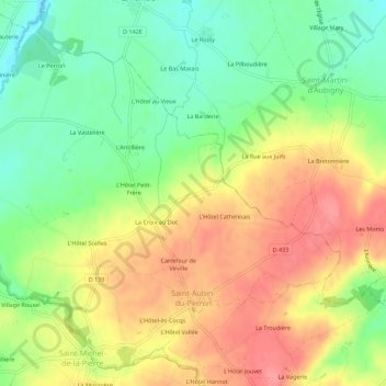
Naam: Topografische kaart Saint-Aubin-du-Perron, hoogte, reliëf.
Gemiddelde hoogte: 54 m
Minimale hoogte: 15 m
Maximale hoogte: 93 m
L'altitude est comprise entre 15 et 88 mètres, le territoire couvre 762 hectares.
Andere topografische kaarten
Klik op een kaart om zijn topografie, zijn hoogte en zijn reliëf te bekijken.
La Barbe
France > Normandie > Manche > Saint-Sauveur-Villages > Le Mesnilbus
La Barbe, Le Mesnilbus, Saint-Sauveur-Villages, Coutances, Manche, Normandie, France métropolitaine, 50490, France
Gemiddelde hoogte: 74 m
Le Mesnil Yserand
France > Normandie > Manche > Saint-Sauveur-Villages > La Ronde-Haye
Le Mesnil Yserand, La Ronde-Haye, Saint-Sauveur-Villages, Coutances, Manche, Normandie, France métropolitaine, 50490, France
Gemiddelde hoogte: 47 m
La Troudière
France > Normandie > Manche > Saint-Sauveur-Villages > Le Mesnilbus > La Troudière
La Troudière, Le Mesnilbus, Saint-Sauveur-Villages, Coutances, Manche, Normandie, France métropolitaine, 50490, France
Gemiddelde hoogte: 70 m
La Commanderie
France > Normandie > Manche > Saint-Sauveur-Villages > Le Mesnilbus
La Commanderie, Le Mesnilbus, Saint-Sauveur-Villages, Coutances, Manche, Normandie, France métropolitaine, 50490, France
Gemiddelde hoogte: 77 m
Lastelle
France > Normandie > Manche > Saint-Sauveur-Villages > Saint-Sauveur-Lendelin
Lastelle, Saint-Sauveur-Lendelin, Saint-Sauveur-Villages, Coutances, Manche, Normandie, France métropolitaine, 50490, France
Gemiddelde hoogte: 65 m
Le Mesnilbus
France > Normandie > Manche > Saint-Sauveur-Villages
Le Mesnilbus, Saint-Sauveur-Villages, Coutances, Manche, Normandie, France métropolitaine, 50490, France
Gemiddelde hoogte: 77 m
La Patinière
France > Normandie > Manche > Saint-Sauveur-Villages > Le Mesnilbus
La Patinière, Le Mesnilbus, Saint-Sauveur-Villages, Coutances, Manche, Normandie, France métropolitaine, 50490, France
Gemiddelde hoogte: 77 m
Ancteville
France > Normandie > Manche > Saint-Sauveur-Villages
Ancteville, Saint-Sauveur-Villages, Coutances, Manche, Normandie, France métropolitaine, 50200, France
Gemiddelde hoogte: 73 m
Saint-Sauveur-Lendelin
France > Normandie > Manche > Saint-Sauveur-Villages
Saint-Sauveur-Lendelin, Saint-Sauveur-Villages, Coutances, Manche, Normandie, France métropolitaine, 50490, France
Gemiddelde hoogte: 65 m
Saint-Michel-de-la-Pierre
France > Normandie > Manche > Saint-Sauveur-Villages
Saint-Michel-de-la-Pierre, Saint-Sauveur-Villages, Coutances, Manche, Normandie, France métropolitaine, 50490, France
Gemiddelde hoogte: 68 m