
Topografische kaart Le Mesnilbus
Interactieve kaart
Klik op de kaart om de hoogte weer te geven.
Over deze kaart
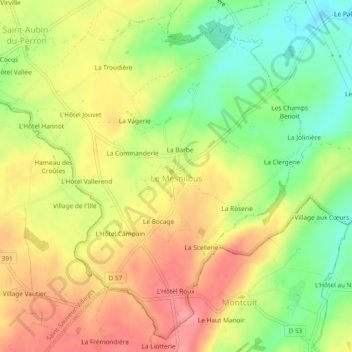
Naam: Topografische kaart Le Mesnilbus, hoogte, reliëf.
Gemiddelde hoogte: 77 m
Minimale hoogte: 27 m
Maximale hoogte: 121 m
Andere topografische kaarten
Klik op een kaart om zijn topografie, zijn hoogte en zijn reliëf te bekijken.
La Barbe
France > Normandie > Manche > Saint-Sauveur-Villages > Le Mesnilbus
La Barbe, Le Mesnilbus, Saint-Sauveur-Villages, Coutances, Manche, Normandie, France métropolitaine, 50490, France
Gemiddelde hoogte: 74 m
Le Mesnil Yserand
France > Normandie > Manche > Saint-Sauveur-Villages > La Ronde-Haye
Le Mesnil Yserand, La Ronde-Haye, Saint-Sauveur-Villages, Coutances, Manche, Normandie, France métropolitaine, 50490, France
Gemiddelde hoogte: 47 m
La Troudière
France > Normandie > Manche > Saint-Sauveur-Villages > Le Mesnilbus > La Troudière
La Troudière, Le Mesnilbus, Saint-Sauveur-Villages, Coutances, Manche, Normandie, France métropolitaine, 50490, France
Gemiddelde hoogte: 70 m
La Commanderie
France > Normandie > Manche > Saint-Sauveur-Villages > Le Mesnilbus
La Commanderie, Le Mesnilbus, Saint-Sauveur-Villages, Coutances, Manche, Normandie, France métropolitaine, 50490, France
Gemiddelde hoogte: 77 m
Lastelle
France > Normandie > Manche > Saint-Sauveur-Villages > Saint-Sauveur-Lendelin
Lastelle, Saint-Sauveur-Lendelin, Saint-Sauveur-Villages, Coutances, Manche, Normandie, France métropolitaine, 50490, France
Gemiddelde hoogte: 65 m
La Patinière
France > Normandie > Manche > Saint-Sauveur-Villages > Le Mesnilbus
La Patinière, Le Mesnilbus, Saint-Sauveur-Villages, Coutances, Manche, Normandie, France métropolitaine, 50490, France
Gemiddelde hoogte: 77 m
Ancteville
France > Normandie > Manche > Saint-Sauveur-Villages
Ancteville, Saint-Sauveur-Villages, Coutances, Manche, Normandie, France métropolitaine, 50200, France
Gemiddelde hoogte: 73 m
Saint-Sauveur-Lendelin
France > Normandie > Manche > Saint-Sauveur-Villages
Saint-Sauveur-Lendelin, Saint-Sauveur-Villages, Coutances, Manche, Normandie, France métropolitaine, 50490, France
Gemiddelde hoogte: 65 m
Saint-Aubin-du-Perron
France > Normandie > Manche > Saint-Sauveur-Villages
Saint-Aubin-du-Perron, Saint-Sauveur-Villages, Coutances, Manche, Normandie, France métropolitaine, 50490, France
Gemiddelde hoogte: 54 m
Saint-Michel-de-la-Pierre
France > Normandie > Manche > Saint-Sauveur-Villages
Saint-Michel-de-la-Pierre, Saint-Sauveur-Villages, Coutances, Manche, Normandie, France métropolitaine, 50490, France
Gemiddelde hoogte: 68 m