
Topografische kaart Geraldton
Klik op de kaart om de hoogte weer te geven.
Over deze kaart
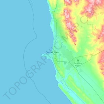
Naam: Topografische kaart Geraldton, hoogte, reliëf.
Locatie: Geraldton, Western Australia, 6530, Australia (-28.93035 114.45472 -28.61035 114.77472)
Gemiddelde hoogte: 33 m
Minimale hoogte: -1 m
Maximale hoogte: 223 m
Andere topografische kaarten
Klik op een kaart om zijn topografie, zijn hoogte en zijn reliëf te bekijken.
Henley Brook
Henley Brook is situated on the flood plains of the Swan River, with regularly occurring seasonal floods. Two ephemeral streams from the river - Henley Brook and St. Leonard's Creek - traverse the suburb. Henley Brook is in the north-east near Brockman Street, while St Leonards Creek traverses the centre of…
Gemiddelde hoogte: 28 m