
Topografische kaart Helleville
Interactieve kaart
Klik op de kaart om de hoogte weer te geven.
Over deze kaart
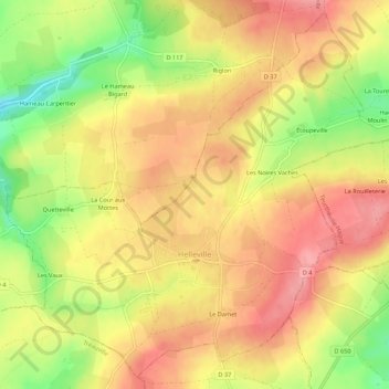
Naam: Topografische kaart Helleville, hoogte, reliëf.
Gemiddelde hoogte: 100 m
Minimale hoogte: 37 m
Maximale hoogte: 141 m
Andere topografische kaarten
Klik op een kaart om zijn topografie, zijn hoogte en zijn reliëf te bekijken.
Cherbourg-en-Cotentin
Cherbourg-en-Cotentin, Cherbourg, Manche, Normandie, France métropolitaine, France
Gemiddelde hoogte: 67 m
Rauville-la-Bigot
Rauville-la-Bigot, Cherbourg, Manche, Normandie, France métropolitaine, 50260, France
Gemiddelde hoogte: 105 m
Kairon
France > Normandie > Manche > Saint-Pair-sur-Mer
Kairon, Saint-Pair-sur-Mer, Avranches, Manche, Normandie, France métropolitaine, 50380, France
Gemiddelde hoogte: 26 m
Monthuchon
Monthuchon, Coutances, Manche, Normandie, France métropolitaine, 50200, France
Gemiddelde hoogte: 116 m
Hacouville
France > Normandie > Manche > Saint-Pierre-Église
Hacouville, Saint-Pierre-Église, Cherbourg, Manche, Normandie, France métropolitaine, 50330, France
Gemiddelde hoogte: 38 m
Saint-Sauveur-de-Pierrepont
Saint-Sauveur-de-Pierrepont, Coutances, Manche, Normandie, France métropolitaine, 50250, France
Gemiddelde hoogte: 26 m
Giéville
France > Normandie > Manche > Torigny-les-Villes
Giéville, Torigny-les-Villes, Saint-Lô, Manche, Normandie, France métropolitaine, 50160, France
Gemiddelde hoogte: 119 m
Beaumont-Hague
France > Normandie > Manche > La Hague
Beaumont-Hague, La Hague, Cherbourg, Manche, Normandie, France métropolitaine, 50440, France
Gemiddelde hoogte: 126 m
Moyon
France > Normandie > Manche > Moyon Villages
Moyon, Moyon Villages, Saint-Lô, Manche, Normandie, France métropolitaine, 50860, France
Gemiddelde hoogte: 100 m
Sainte-Suzanne-sur-Vire
Sainte-Suzanne-sur-Vire, Saint-Lô, Manche, Normandie, France métropolitaine, 50750, France
Gemiddelde hoogte: 62 m
Le Frechot
France > Normandie > Manche > Le Grand-Celland
Le Frechot, Le Grand-Celland, Avranches, Manche, Normandie, France métropolitaine, 50370, France
Gemiddelde hoogte: 177 m
Terre-et-Marais
Terre-et-Marais, Saint-Lô, Manche, Normandie, France métropolitaine, 50500, France
Gemiddelde hoogte: 12 m
Saint-Pierre-Église
Saint-Pierre-Église, Cherbourg, Manche, Normandie, France métropolitaine, 50330, France
Gemiddelde hoogte: 65 m
Hardinvast
Hardinvast, Cherbourg, Manche, Normandie, France métropolitaine, 50690, France
Gemiddelde hoogte: 105 m
Le Hamel Godard
France > Normandie > Manche > Montabot
Le Hamel Godard, Montabot, Saint-Lô, Manche, Normandie, France métropolitaine, 50410, France
Gemiddelde hoogte: 185 m
Carantilly
Carantilly, Saint-Lô, Manche, Normandie, France métropolitaine, 50570, France
Gemiddelde hoogte: 97 m
Saint-Hilaire-du-Harcouët
France > Normandie > Manche > Saint-Hilaire-du-Harcouët
Saint-Hilaire-du-Harcouët, Avranches, Manche, Normandie, France métropolitaine, 50600, France
Gemiddelde hoogte: 92 m
Saint-Germain-d'Elle
Saint-Germain-d'Elle, Saint-Lô, Manche, Normandie, France métropolitaine, 50810, France
Gemiddelde hoogte: 136 m
Le Mesnil-Gilbert
Le Mesnil-Gilbert, Avranches, Manche, Normandie, France métropolitaine, 50670, France
Gemiddelde hoogte: 91 m
Gréville-Hague
France > Normandie > Manche > La Hague
Gréville-Hague, La Hague, Cherbourg, Manche, Normandie, France métropolitaine, 50440, France
Gemiddelde hoogte: 107 m
Hameau aux Ducs
France > Normandie > Manche > La Hague > Gréville-Hague
Hameau aux Ducs, Gréville-Hague, La Hague, Cherbourg, Manche, Normandie, France métropolitaine, 50440, France
Gemiddelde hoogte: 74 m
Saint-Jean-des-Baisants
Saint-Jean-des-Baisants, Saint-Jean-d'Elle, Saint-Lô, Manche, Normandie, France métropolitaine, 50810, France
Gemiddelde hoogte: 139 m
Sainte-Croix-Hague
France > Normandie > Manche > La Hague
Sainte-Croix-Hague, La Hague, Cherbourg, Manche, Normandie, France métropolitaine, 50440, France
Gemiddelde hoogte: 143 m
50810
France > Normandie > Manche > Saint-Jean-des-Baisants > Les Epinets
50810, Les Epinets, Saint-Jean-des-Baisants, Saint-Jean-d'Elle, Saint-Lô, Manche, Normandie, France métropolitaine, France
Gemiddelde hoogte: 148 m
Yvetot-Bocage
Yvetot-Bocage, Cherbourg, Manche, Normandie, France métropolitaine, 50700, France
Gemiddelde hoogte: 32 m
Le Domaine
France > Normandie > Manche > Le Teilleul
Le Domaine, Le Teilleul, Avranches, Manche, Normandie, France métropolitaine, 50640, France
Gemiddelde hoogte: 167 m
La Huberdière
France > Normandie > Manche > Surville
La Huberdière, Surville, La Haye, Coutances, Manche, Normandie, France métropolitaine, 50250, France
Gemiddelde hoogte: 10 m
50420
France > Normandie > Manche > Tessy-Bocage
50420, Tessy-sur-Vire, Tessy-Bocage, Saint-Lô, Manche, Normandie, France métropolitaine, France
Gemiddelde hoogte: 73 m
L'Hôtel Massu
France > Normandie > Manche > La Colombe
L'Hôtel Massu, La Colombe, Saint-Lô, Manche, Normandie, France métropolitaine, 50800, France
Gemiddelde hoogte: 147 m
Le Pont Rose
France > Normandie > Manche > Barneville-Carteret
Le Pont Rose, Barneville-Carteret, Cherbourg, Manche, Normandie, France métropolitaine, 50270, France
Gemiddelde hoogte: 37 m
Le Hardelle
France > Normandie > Manche > Bretteville
Le Hardelle, Bretteville, Cherbourg, Manche, Normandie, France métropolitaine, 50110, France
Gemiddelde hoogte: 50 m
Gonfreville
Gonfreville, Coutances, Manche, Normandie, France métropolitaine, 50190, France
Gemiddelde hoogte: 15 m
Moyon Villages
Moyon Villages, Saint-Lô, Manche, Normandie, France métropolitaine, 50860, France
Gemiddelde hoogte: 108 m
Herqueville
France > Normandie > Manche > La Hague
Herqueville, La Hague, Cherbourg, Manche, Normandie, France métropolitaine, 50440, France
Gemiddelde hoogte: 112 m