
Topografische kaart Highland County
Interactieve kaart
Klik op de kaart om de hoogte weer te geven.
Over deze kaart
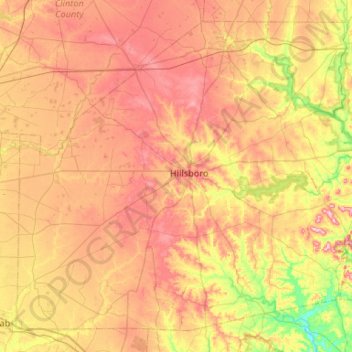
Naam: Topografische kaart Highland County, hoogte, reliëf.
Locatie: Highland County, Ohio, United States of America (39.01846 -83.87217 39.37876 -83.34395)
Gemiddelde hoogte: 305 m
Minimale hoogte: 203 m
Maximale hoogte: 401 m
Highland County is a county located in the U.S. state of Ohio. As of the 2010 census, the population was 43,589. Its county seat is Hillsboro. The county is named for the topography which is hilly and divides the watersheds of the Little Miami and Scioto Rivers.
Andere topografische kaarten
Klik op een kaart om zijn topografie, zijn hoogte en zijn reliëf te bekijken.
Allen County
United States of America > Ohio
Allen County, Ohio, United States of America
Gemiddelde hoogte: 264 m
Summit County
United States of America > Ohio
Summit County, Ohio, United States of America
Gemiddelde hoogte: 327 m
Kimbolton
United States of America > Ohio > Kimbolton
Kimbolton, Guernsey County, Ohio, 43749, United States of America
Gemiddelde hoogte: 275 m
Ottawa County
United States of America > Ohio
Ottawa County, Ohio, United States of America
Gemiddelde hoogte: 180 m